Priboj geodata
Priboj (Srpska) is a populated place; located in Bosnia and Herzegovina in Europe/Sarajevo (GMT+2) time zone. With population of 4,351 people, there are 144 cities with bigger population in this country. Compared to other cities in Bosnia and Herzegovina, 59.6% of cities are located further ↓South; 90.6% of cities are located further ←West and 57.7% of cities have higher elevation than Priboj. Note1


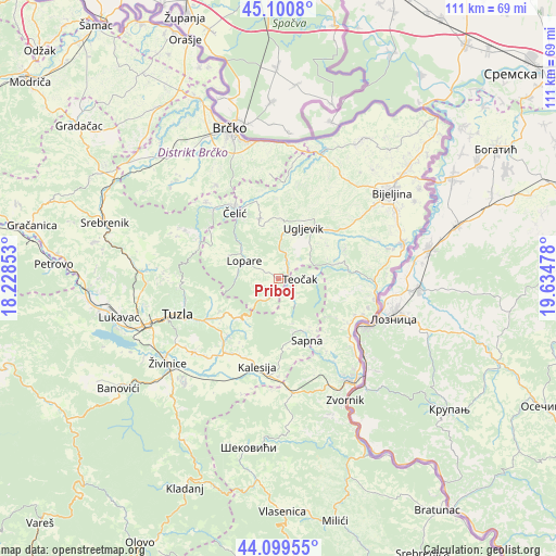
Priboj GPS coordinates[2]
44° 36' 8.388" North, 18° 55' 53.94" East
| Map corner | latitude | longitude |
|---|---|---|
| Upper-left | 45.1008°, | 18.22853° |
| Center: | 44.60233°, | 18.93165° |
| Lower-right: | 44.09955°, | 19.63478° |
| Map W x H: | 111.3×111.3 km | = 69.2×69.2mi |
| max Lat: | 45.21956° ⇑40.4% North |
| Priboj: | 44.60233° |
| min Lat: | ⇓59.6% South 42.71197° |
| min Long | Priboj | max Long |
| 15.77806° | 18.93165° | 19.36719° |
| W 90.6%⇐ | ⇒9.4% E |
Elevation
Elevation of Priboj is 251 m = 823 ft, and this is 108.5 m = 356 ft below average elevation for this country.
| Max E: |
1175 m = 3855 ft | 57.7% |
| Avg. | 359.5 m = 1179 ft | |
| Priboj | 251 m = 823 ft | |
Min E: |
17 m = 56 ft | 42.3% |
See also: Bosnia and Herzegovina elevation on elevation.city.
Geographical zone
Priboj is located in North temperate zone (between Tropic of Cancer and the Arctic Circle). Distance of this Northern Tropic circle is 2353.4 km =1462.3 mi to South.| Distance of | km | miles | from Priboj |
|---|---|---|---|
| North Pole | 5047.7 | 3136.5 | to North |
| Arctic Circle | 2441.9 | 1517.3 | to North |
| Tropic Cancer | 2353.4 | 1462.3 | to South |
| Equator | 4959.3 | 3081.6 | to South |


Nearby cities:
15 places around Priboj: (largest is in red/bold)
• Dubrave Donje
23 km =14.3 mi,  233°
233°
• Dubrave Gornje
21.7 km =13.5 mi, 228°
• Gornja Tuzla
14.4 km =8.9 mi,  249°
249°
• Kalesija
18.4 km =11.4 mi,  186°
186°
• Lopare
7.9 km =4.9 mi,  297°
297°
• Osmaci
22.4 km =13.9 mi,  183°
183°
• Petkovci
18.7 km =11.6 mi,  142°
142°
• Sapna
12.2 km =7.6 mi,  154°
154°
• Solina
19.4 km =12.1 mi,  256°
256°
• Teočak
3.8 km =2.4 mi,  88°
88°
• Tojšići
16.1 km =10 mi, 225°
• Tuzla
22.1 km =13.7 mi, 251°
• Ugljevik
9.8 km =6.1 mi,  45°
45°
• Vukovije Donje
21.3 km =13.2 mi,  222°
222°
• Čelić
16.5 km =10.3 mi,  325°
325°
Sources, notices
• [Note1] Compared only with cities in Bosnia and Herzegovina existing in our database
• [Src1] Map data: © OpenStreetMap contributors (CC-BY-SA)
• [Src2] Other city data from geonames.org with taken over terms of usage.
• [Src3] Geographical zone / Annual Mean Temperature by Robert A. Rohde @ Wikipedia
