Pale geodata
Pale (Srpska) is a seat of a third-order administrative division; located in Bosnia and Herzegovina in Europe/Sarajevo (GMT+2) time zone. With population of 7,458 people, there are 59 cities with bigger population in this country. Compared to other cities in Bosnia and Herzegovina, 80% of cities are located further ↑North; 77.7% of cities are located further ←West and 92.8% of cities have lower elevation than Pale. Note1


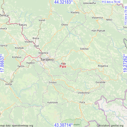
Pale GPS coordinates[2]
43° 48' 59.904" North, 18° 34' 10.164" East
| Map corner | latitude | longitude |
|---|---|---|
| Upper-left | 44.32183°, | 17.86637° |
| Center: | 43.81664°, | 18.56949° |
| Lower-right: | 43.30714°, | 19.27262° |
| Map W x H: | 112.8×112.8 km | = 70.1×70.1mi |
| max Lat: | 45.21956° ⇑80% North |
| Pale: | 43.81664° |
| min Lat: | ⇓20% South 42.71197° |
| min Long | Pale | max Long |
| 15.77806° | 18.56949° | 19.36719° |
| W 77.7%⇐ | ⇒22.3% E |
Elevation
Elevation of Pale is 834 m = 2736 ft, and this is 474.5 m = 1557 ft above average elevation for this country.
| Max E: |
1175 m = 3855 ft | 7.2% |
| Pale | 834 m 2736 ft | |
| Avg. | 359.5 m = 1179 ft | |
Min E: |
17 m = 56 ft | 92.8% |
See also: Bosnia and Herzegovina elevation on elevation.city.
Geographical zone
Pale is located in North temperate zone (between Tropic of Cancer and the Arctic Circle). Distance of this Northern Tropic circle is 2266 km =1408 mi to South.| Distance of | km | miles | from Pale |
|---|---|---|---|
| North Pole | 5135.1 | 3190.8 | to North |
| Arctic Circle | 2529.2 | 1571.6 | to North |
| Tropic Cancer | 2266 | 1408 | to South |
| Equator | 4872 | 3027.3 | to South |


Nearby cities:
15 places around Pale: (largest is in red/bold)
• Gračanica
24.8 km =15.4 mi,  248°
248°
• Hadžići
29.1 km =18.1 mi,  271°
271°
• Hotonj
17.6 km =10.9 mi,  299°
299°
• Hreša
9 km =5.6 mi,  319°
319°
• Ilidža
21.7 km =13.5 mi, 273°
• Ilijaš
28.2 km =17.5 mi, 302°
• Kobilja Glava
16.2 km =10.1 mi, 296°
• Koran
0.7 km =0.4 mi,  176°
176°
• Lukavica
15 km =9.3 mi, 274°
• Prača
16.8 km =10.4 mi,  110°
110°
• Sarajevo
17.5 km =10.9 mi,  281°
281°
• Sokolac
22.9 km =14.2 mi,  53°
53°
• Trnovo
19.5 km =12.1 mi,  210°
210°
• Ustikolina
31.5 km =19.6 mi,  145°
145°
• Vogošća
20.4 km =12.7 mi, 297°
Sources, notices
• [Note1] Compared only with cities in Bosnia and Herzegovina existing in our database
• [Src1] Map data: © OpenStreetMap contributors (CC-BY-SA)
• [Src2] Other city data from geonames.org with taken over terms of usage.
• [Src3] Geographical zone / Annual Mean Temperature by Robert A. Rohde @ Wikipedia
