Sarajevo geodata
Sarajevo (Federation of B&H) is a capital of a political entity; located in Bosnia and Herzegovina in Europe/Sarajevo (GMT+2) time zone. With population of 696,731 people, there are 0 cities with bigger population in this country. Compared to other cities in Bosnia and Herzegovina, 77.4% of cities are located further ↑North; 68.3% of cities are located further ←West and 77.7% of cities have lower elevation than Sarajevo. Note1


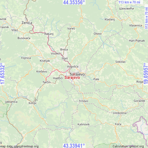
Sarajevo GPS coordinates[2]
43° 50' 55.104" North, 18° 21' 23.184" East
| Map corner | latitude | longitude |
|---|---|---|
| Upper-left | 44.35356°, | 17.65332° |
| Center: | 43.84864°, | 18.35644° |
| Lower-right: | 43.33941°, | 19.05957° |
| Map W x H: | 112.8×112.8 km | = 70.1×70.1mi |
| max Lat: | 45.21956° ⇑77.4% North |
| Sarajevo: | 43.84864° |
| min Lat: | ⇓22.6% South 42.71197° |
| min Long | Sarajevo | max Long |
| 15.77806° | 18.35644° | 19.36719° |
| W 68.3%⇐ | ⇒31.7% E |
Elevation
Elevation of Sarajevo is 509 m = 1670 ft, and this is 149.5 m = 490 ft above average elevation for this country.
| Max E: |
1175 m = 3855 ft | 22.3% |
| Sarajevo | 509 m 1670 ft | |
| Avg. | 359.5 m = 1179 ft | |
Min E: |
17 m = 56 ft | 77.7% |
See also: Sarajevo elevation on elevation.city.
Geographical zone
Sarajevo is located in North temperate zone (between Tropic of Cancer and the Arctic Circle). Distance of this Northern Tropic circle is 2269.6 km =1410.3 mi to South.| Distance of | km | miles | from Sarajevo |
|---|---|---|---|
| North Pole | 5131.6 | 3188.6 | to North |
| Arctic Circle | 2525.7 | 1569.4 | to North |
| Tropic Cancer | 2269.6 | 1410.3 | to South |
| Equator | 4875.5 | 3029.5 | to South |


Nearby cities:
15 places around Sarajevo: (largest is in red/bold)
• Breza
20.4 km =12.7 mi,  337°
337°
• Gračanica
14.1 km =8.8 mi,  204°
204°
• Hadžići
12.4 km =7.7 mi,  256°
256°
• Hotonj
5.3 km =3.3 mi,  18°
18°
• Hreša
11.7 km =7.3 mi,  73°
73°
• Ilidža
5 km =3.1 mi,  244°
244°
• Ilijaš
13.3 km =8.3 mi,  329°
329°
• Kobilja Glava
4.5 km =2.8 mi,  34°
34°
• Koran
17.6 km =10.9 mi,  103°
103°
• Lukavica
3.2 km =2 mi,  138°
138°
• Mahala
19.9 km =12.4 mi, 335°
• Pale
17.5 km =10.9 mi, 101°
• Pazarić
17.1 km =10.6 mi,  247°
247°
• Visoko
21.1 km =13.1 mi,  317°
317°
• Vogošća
6 km =3.7 mi,  350°
350°
Sources, notices
• [Note1] Compared only with cities in Bosnia and Herzegovina existing in our database
• [Src1] Map data: © OpenStreetMap contributors (CC-BY-SA)
• [Src2] Other city data from geonames.org with taken over terms of usage.
• [Src3] Geographical zone / Annual Mean Temperature by Robert A. Rohde @ Wikipedia
