Hotonj geodata
Hotonj (Federation of B&H) is a populated locality; located in Bosnia and Herzegovina in Europe/Sarajevo (GMT+2) time zone. With population of 4,013 people, there are 158 cities with bigger population in this country. Compared to other cities in Bosnia and Herzegovina, 75.1% of cities are located further ↑North; 69.1% of cities are located further ←West and 82.3% of cities have lower elevation than Hotonj. Note1


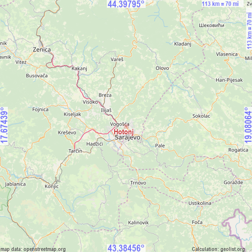
Hotonj GPS coordinates[2]
43° 53' 36.276" North, 18° 22' 39.036" East
| Map corner | latitude | longitude |
|---|---|---|
| Upper-left | 44.39795°, | 17.67439° |
| Center: | 43.89341°, | 18.37751° |
| Lower-right: | 43.38456°, | 19.08064° |
| Map W x H: | 112.7×112.7 km | = 70×70mi |
| max Lat: | 45.21956° ⇑75.1% North |
| Hotonj: | 43.89341° |
| min Lat: | ⇓24.9% South 42.71197° |
| min Long | Hotonj | max Long |
| 15.77806° | 18.37751° | 19.36719° |
| W 69.1%⇐ | ⇒30.9% E |
Elevation
Elevation of Hotonj is 571 m = 1873 ft, and this is 211.5 m = 694 ft above average elevation for this country.
| Max E: |
1175 m = 3855 ft | 17.7% |
| Hotonj | 571 m 1873 ft | |
| Avg. | 359.5 m = 1179 ft | |
Min E: |
17 m = 56 ft | 82.3% |
See also: Bosnia and Herzegovina elevation on elevation.city.
Geographical zone
Hotonj is located in North temperate zone (between Tropic of Cancer and the Arctic Circle). Distance of this Northern Tropic circle is 2274.6 km =1413.4 mi to South.| Distance of | km | miles | from Hotonj |
|---|---|---|---|
| North Pole | 5126.6 | 3185.5 | to North |
| Arctic Circle | 2520.7 | 1566.3 | to North |
| Tropic Cancer | 2274.6 | 1413.4 | to South |
| Equator | 4880.5 | 3032.6 | to South |


Nearby cities:
15 places around Hotonj: (largest is in red/bold)
• Breza
16.8 km =10.4 mi,  326°
326°
• Gornja Breza
19.2 km =11.9 mi, 326°
• Gračanica
19.3 km =12 mi,  203°
203°
• Hadžići
15.8 km =9.8 mi,  239°
239°
• Hreša
9.7 km =6 mi,  100°
100°
• Ilidža
9.4 km =5.8 mi,  221°
221°
• Ilijaš
10.7 km =6.6 mi,  307°
307°
• Kobilja Glava
1.6 km =1 mi,  145°
145°
• Koran
18 km =11.2 mi,  120°
120°
• Lukavica
7.4 km =4.6 mi,  176°
176°
• Mahala
16.4 km =10.2 mi,  323°
323°
• Pale
17.6 km =10.9 mi, 119°
• Sarajevo
5.3 km =3.3 mi, 198°
• Visoko
19.2 km =11.9 mi,  303°
303°
• Vogošća
2.8 km =1.7 mi,  290°
290°
Sources, notices
• [Note1] Compared only with cities in Bosnia and Herzegovina existing in our database
• [Src1] Map data: © OpenStreetMap contributors (CC-BY-SA)
• [Src2] Other city data from geonames.org with taken over terms of usage.
• [Src3] Geographical zone / Annual Mean Temperature by Robert A. Rohde @ Wikipedia
