Orguz geodata
Orguz (Federation of B&H) is a populated place; located in Bosnia and Herzegovina in Europe/Sarajevo (GMT+2) time zone. With population of 4,371 people, there are 142 cities with bigger population in this country. Compared to other cities in Bosnia and Herzegovina, 82.6% of cities are located further ↑North; 82.3% of cities are located further →East and 88.7% of cities have lower elevation than Orguz. Note1


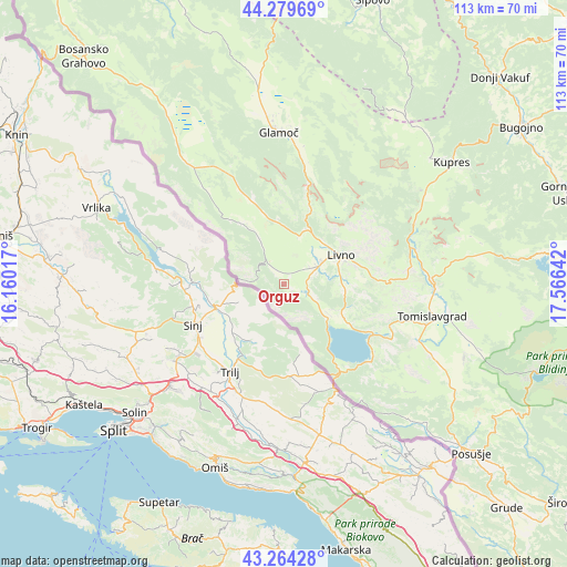
Orguz GPS coordinates[2]
43° 46' 26.904" North, 16° 51' 47.844" East
| Map corner | latitude | longitude |
|---|---|---|
| Upper-left | 44.27969°, | 16.16017° |
| Center: | 43.77414°, | 16.86329° |
| Lower-right: | 43.26428°, | 17.56642° |
| Map W x H: | 112.9×112.9 km | = 70.2×70.2mi |
| max Lat: | 45.21956° ⇑82.6% North |
| Orguz: | 43.77414° |
| min Lat: | ⇓17.4% South 42.71197° |
| min Long | Orguz | max Long |
| 15.77806° | 16.86329° | 19.36719° |
| W 17.7%⇐ | ⇒82.3% E |
Elevation
Elevation of Orguz is 721 m = 2365 ft, and this is 361.5 m = 1186 ft above average elevation for this country.
| Max E: |
1175 m = 3855 ft | 11.3% |
| Orguz | 721 m 2365 ft | |
| Avg. | 359.5 m = 1179 ft | |
Min E: |
17 m = 56 ft | 88.7% |
See also: Bosnia and Herzegovina elevation on elevation.city.
Geographical zone
Orguz is located in North temperate zone (between Tropic of Cancer and the Arctic Circle). Distance of this Northern Tropic circle is 2261.3 km =1405.1 mi to South.| Distance of | km | miles | from Orguz |
|---|---|---|---|
| North Pole | 5139.8 | 3193.7 | to North |
| Arctic Circle | 2533.9 | 1574.5 | to North |
| Tropic Cancer | 2261.3 | 1405.1 | to South |
| Equator | 4867.2 | 3024.3 | to South |


Nearby cities:
15 places around Orguz: (largest is in red/bold)
• Bila
5.2 km =3.2 mi,  79°
79°
• Bugojno
56.6 km =35.2 mi,  56°
56°
• Drežnica
43.3 km =26.9 mi,  129°
129°
• Glamoč
30.2 km =18.8 mi,  357°
357°
• Gorica
52.1 km =32.4 mi,  139°
139°
• Kupres
41.1 km =25.5 mi,  53°
53°
• Livno
13 km =8.1 mi, 63°
• Novo Selo
41.3 km =25.7 mi,  34°
34°
• Pajić Polje
57.8 km =35.9 mi,  67°
67°
• Podhum
12.3 km =7.6 mi,  117°
117°
• Posušje
50.1 km =31.1 mi, 131°
• Rumboci
51.7 km =32.1 mi, 82°
• Tomislavgrad
29.7 km =18.5 mi,  102°
102°
• Vidoši
13.3 km =8.3 mi,  91°
91°
• Zabrišće
6.6 km =4.1 mi, 72°
Sources, notices
• [Note1] Compared only with cities in Bosnia and Herzegovina existing in our database
• [Src1] Map data: © OpenStreetMap contributors (CC-BY-SA)
• [Src2] Other city data from geonames.org with taken over terms of usage.
• [Src3] Geographical zone / Annual Mean Temperature by Robert A. Rohde @ Wikipedia
