Gradiška geodata
Gradiška (Srpska) is a seat of a second-order administrative division; located in Bosnia and Herzegovina in Europe/Sarajevo (GMT+2) time zone. With population of 13,346 people, there are 26 cities with bigger population in this country. Compared to other cities in Bosnia and Herzegovina, 97.4% of cities are located further ↓South; 74% of cities are located further →East and 91.7% of cities have higher elevation than Gradiška. Note1


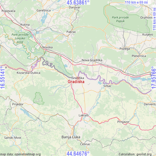
Gradiška GPS coordinates[2]
45° 8' 41.424" North, 17° 15' 16.308" East
| Map corner | latitude | longitude |
|---|---|---|
| Upper-left | 45.63861°, | 16.55141° |
| Center: | 45.14484°, | 17.25453° |
| Lower-right: | 44.64676°, | 17.95766° |
| Map W x H: | 110.3×110.3 km | = 68.5×68.5mi |
| max Lat: | 45.21956° ⇑2.6% North |
| Gradiška: | 45.14484° |
| min Lat: | ⇓97.4% South 42.71197° |
| min Long | Gradiška | max Long |
| 15.77806° | 17.25453° | 19.36719° |
| W 26%⇐ | ⇒74% E |
Elevation
Elevation of Gradiška is 91 m = 299 ft, and this is 268.5 m = 881 ft below average elevation for this country.
| Max E: |
1175 m = 3855 ft | 91.7% |
| Avg. | 359.5 m = 1179 ft | |
| Gradiška | 91 m = 299 ft | |
Min E: |
17 m = 56 ft | 8.3% |
See also: Bosnia and Herzegovina elevation on elevation.city.
Geographical zone
Gradiška is located in North temperate zone (between Tropic of Cancer and the Arctic Circle). Distance of this North polar circle is 2381.5 km =1479.8 mi to North.| Distance of | km | miles | from Gradiška |
|---|---|---|---|
| North Pole | 4987.4 | 3099 | to North |
| Arctic Circle | 2381.5 | 1479.8 | to North |
| Tropic Cancer | 2413.7 | 1499.8 | to South |
| Equator | 5019.6 | 3119 | to South |


Nearby cities:
15 places around Gradiška: (largest is in red/bold)
• Banja Luka
41 km =25.5 mi,  186°
186°
• Hiseti
43.1 km =26.8 mi, 187°
• Kozarska Dubica
35.1 km =21.8 mi,  275°
275°
• Laktaši
26.5 km =16.5 mi,  172°
172°
• Lamovita
37.5 km =23.3 mi,  228°
228°
• Maglajani
23 km =14.3 mi,  160°
160°
• Marićka
44 km =27.3 mi, 225°
• Mejdan - Obilićevo
42.7 km =26.5 mi, 186°
• Omarska
39.7 km =24.7 mi,  224°
224°
• Piskavica
37.9 km =23.5 mi, 215°
• Prnjavor
44.3 km =27.5 mi,  133°
133°
• Srbac
21.7 km =13.5 mi,  104°
104°
• Starcevica
43.2 km =26.8 mi,  184°
184°
• Trn
31.9 km =19.8 mi, 182°
• Čelinac
45.3 km =28.1 mi, 173°
Sources, notices
• [Note1] Compared only with cities in Bosnia and Herzegovina existing in our database
• [Src1] Map data: © OpenStreetMap contributors (CC-BY-SA)
• [Src2] Other city data from geonames.org with taken over terms of usage.
• [Src3] Geographical zone / Annual Mean Temperature by Robert A. Rohde @ Wikipedia
