Kladanj geodata
Kladanj (Federation of B&H) is a seat of a third-order administrative division; located in Bosnia and Herzegovina in Europe/Sarajevo (GMT+2) time zone. With population of 6,783 people, there are 73 cities with bigger population in this country. Compared to other cities in Bosnia and Herzegovina, 61.5% of cities are located further ↑North; 83% of cities are located further ←West and 82.6% of cities have lower elevation than Kladanj. Note1


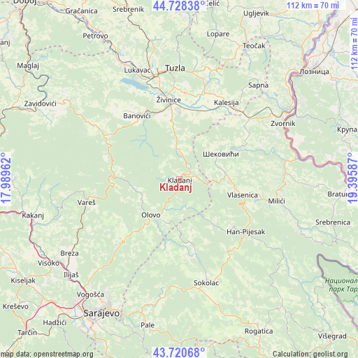
Kladanj GPS coordinates[2]
44° 13' 36.084" North, 18° 41' 33.864" East
| Map corner | latitude | longitude |
|---|---|---|
| Upper-left | 44.72838°, | 17.98962° |
| Center: | 44.22669°, | 18.69274° |
| Lower-right: | 43.72068°, | 19.39587° |
| Map W x H: | 112×112 km | = 69.6×69.6mi |
| max Lat: | 45.21956° ⇑61.5% North |
| Kladanj: | 44.22669° |
| min Lat: | ⇓38.5% South 42.71197° |
| min Long | Kladanj | max Long |
| 15.77806° | 18.69274° | 19.36719° |
| W 83%⇐ | ⇒17% E |
Elevation
Elevation of Kladanj is 572 m = 1877 ft, and this is 212.5 m = 697 ft above average elevation for this country.
| Max E: |
1175 m = 3855 ft | 17.4% |
| Kladanj | 572 m 1877 ft | |
| Avg. | 359.5 m = 1179 ft | |
Min E: |
17 m = 56 ft | 82.6% |
See also: Bosnia and Herzegovina elevation on elevation.city.
Geographical zone
Kladanj is located in North temperate zone (between Tropic of Cancer and the Arctic Circle). Distance of this Northern Tropic circle is 2311.6 km =1436.4 mi to South.| Distance of | km | miles | from Kladanj |
|---|---|---|---|
| North Pole | 5089.5 | 3162.5 | to North |
| Arctic Circle | 2483.6 | 1543.2 | to North |
| Tropic Cancer | 2311.6 | 1436.4 | to South |
| Equator | 4917.5 | 3055.6 | to South |


Nearby cities:
15 places around Kladanj: (largest is in red/bold)
• Banovići
23.9 km =14.9 mi,  326°
326°
• Careva Ćuprija
21.4 km =13.3 mi,  281°
281°
• Dubrave Donje
28.2 km =17.5 mi,  0°
0°
• Dubrave Gornje
27.4 km =17 mi,  5°
5°
• Gornje Živinice
23.3 km =14.5 mi,  344°
344°
• Han Pijesak
26.3 km =16.3 mi,  127°
127°
• Olovo
14.2 km =8.8 mi,  219°
219°
• Osmaci
26.4 km =16.4 mi,  42°
42°
• Stupari
9.7 km =6 mi,  355°
355°
• Svojat
19.1 km =11.9 mi, 10°
• Vlasenica
20.4 km =12.7 mi,  104°
104°
• Vukovije Donje
26.6 km =16.5 mi, 9°
• Šekovići
15.2 km =9.4 mi,  58°
58°
• Šerići
28.6 km =17.8 mi, 338°
• Živinice
25 km =15.5 mi,  352°
352°
Sources, notices
• [Note1] Compared only with cities in Bosnia and Herzegovina existing in our database
• [Src1] Map data: © OpenStreetMap contributors (CC-BY-SA)
• [Src2] Other city data from geonames.org with taken over terms of usage.
• [Src3] Geographical zone / Annual Mean Temperature by Robert A. Rohde @ Wikipedia
