Holetown geodata
Holetown (Saint James) is a seat of a first-order administrative division; located in Barbados in America/Barbados (GMT-4) time zone. With population of 1,350 people, there are 4 cities with bigger population in this country. Compared to other cities in Barbados, 58.3% of cities are located further ↑North; 75% of cities are located further →East and 100% of cities have higher elevation than Holetown. Note1


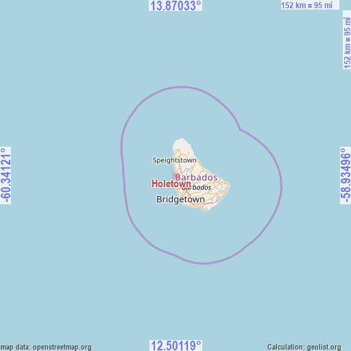
Holetown GPS coordinates[2]
13° 11' 12.192" North, 59° 38' 17.088" West
| Map corner | latitude | longitude |
|---|---|---|
| Upper-left | 13.87033°, | -60.34121° |
| Center: | 13.18672°, | -59.63808° |
| Lower-right: | 12.50119°, | -58.93496° |
| Map W x H: | 152.2×152.2 km | = 94.6×94.6mi |
| max Lat: | 13.3196° ⇑58.3% North |
| Holetown: | 13.18672° |
| min Lat: | ⇓41.7% South 13.07067° |
| min Long | Holetown | max Long |
| -59.64396° | -59.63808° | -59.44861° |
| W 25%⇐ | ⇒75% E |
Elevation
Elevation of Holetown is -1 m = -3 ft, and this is 105.6 m = 346 ft below average elevation for this country.
| Max E: |
302 m = 991 ft | 100% |
| Avg. | 104.6 m = 343 ft | |
| Holetown | -1 m = -3 ft | |
Min E: |
-1 m = -3 ft | 0% |
See also: Barbados elevation on elevation.city.
Geographical zone
Holetown is located in North Torrid zone (between Equator and Tropic of Cancer). Distance of this Northern Tropic circle is 1139.7 km =708.2 mi to North.| Distance of | km | miles | from Holetown |
|---|---|---|---|
| North Pole | 8540.8 | 5307 | to North |
| Arctic Circle | 5934.9 | 3687.8 | to North |
| Tropic Cancer | 1139.7 | 708.2 | to North |
| Equator | 1466.2 | 911.1 | to South |


Nearby cities:
12 places around Holetown: (largest is in red/bold)
• Bathsheba
12.4 km =7.7 mi,  77°
77°
• Blackmans
10.1 km =6.3 mi,  91°
91°
• Bridgetown
9 km =5.6 mi,  167°
167°
• Checker Hall
10.9 km =6.8 mi,  357°
357°
• Crab Hill
14.8 km =9.2 mi, 359°
• Crane
22.4 km =13.9 mi,  113°
113°
• Four Cross Roads
12.7 km =7.9 mi,  98°
98°
• Greenland
10.3 km =6.4 mi,  39°
39°
• Hillaby
6.1 km =3.8 mi,  61°
61°
• Oistins
16.3 km =10.1 mi,  142°
142°
• Speightstown
7.1 km =4.4 mi,  354°
354°
• Welchman Hall
6.7 km =4.2 mi, 89°
Sources, notices
• [Note1] Compared only with cities in Barbados existing in our database
• [Src1] Map data: © OpenStreetMap contributors (CC-BY-SA)
• [Src2] Other city data from geonames.org with taken over terms of usage.
• [Src3] Geographical zone / Annual Mean Temperature by Robert A. Rohde @ Wikipedia
