Mortsel geodata
Mortsel (Flanders) is a populated place; located in Belgium in Europe/Brussels (GMT+2) time zone. With population of 24,525 people, there are 82 cities with bigger population in this country. Compared to other cities in Belgium, 87.4% of cities are located further ↓South; 57.2% of cities are located further →East and 73.1% of cities have higher elevation than Mortsel. Note1
Administrative division(s):
- Level 1: Flanders
- Level 2: Provincie Antwerpen
- Level 3: Arrondissement Antwerpen
- Level 4: Mortsel


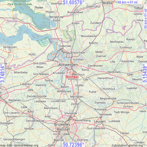
Mortsel GPS coordinates[2]
51° 10' 1.092" North, 4° 27' 4.572" East
| Map corner | latitude | longitude |
|---|---|---|
| Upper-left | 51.60576°, | 3.74814° |
| Center: | 51.16697°, | 4.45127° |
| Lower-right: | 50.72396°, | 5.15439° |
| Map W x H: | 98×98 km | = 60.9×60.9mi |
| max Lat: | 51.46791° ⇑12.6% North |
| Mortsel: | 51.16697° |
| min Lat: | ⇓87.4% South 49.53771° |
| min Long | Mortsel | max Long |
| 2.59368° | 4.45127° | 6.25749° |
| W 42.8%⇐ | ⇒57.2% E |
Elevation
Elevation of Mortsel is 19 m = 62 ft, and this is 80.5 m = 264 ft below average elevation for this country.
| Max E: |
582 m = 1909 ft | 73.1% |
| Avg. | 99.5 m = 326 ft | |
| Mortsel | 19 m = 62 ft | |
Min E: |
1 m = 3 ft | 26.9% |
See also: Belgium elevation on elevation.city.
Geographical zone
Mortsel is located in North temperate zone (between Tropic of Cancer and the Arctic Circle). Distance of this North polar circle is 1711.9 km =1063.7 mi to North.| Distance of | km | miles | from Mortsel |
|---|---|---|---|
| North Pole | 4317.8 | 2683 | to North |
| Arctic Circle | 1711.9 | 1063.7 | to North |
| Tropic Cancer | 3083.3 | 1915.9 | to South |
| Equator | 5689.2 | 3535.1 | to South |


Nearby cities:
15 places around Mortsel: (largest is in red/bold)
• Aartselaar
5.8 km =3.6 mi,  230°
230°
• Antwerpen
6.8 km =4.2 mi,  330°
330°
• Boechout
3 km =1.9 mi,  106°
106°
• Borsbeek
4.1 km =2.5 mi,  35°
35°
• Deurne
6.1 km =3.8 mi,  9°
9°
• Duffel
8.9 km =5.5 mi,  153°
153°
• Edegem
1.2 km =0.7 mi,  200°
200°
• Hemiksem
8.2 km =5.1 mi,  252°
252°
• Hoboken
7.2 km =4.5 mi,  278°
278°
• Hove
1.9 km =1.2 mi,  135°
135°
• Kontich
3.9 km =2.4 mi,  184°
184°
• Lint
5.5 km =3.4 mi, 144°
• Ranst
8.3 km =5.2 mi,  72°
72°
• Wijnegem
8.3 km =5.2 mi,  34°
34°
• Wommelgem
6.5 km =4 mi,  49°
49°
Sources, notices
• [Note1] Compared only with cities in Belgium existing in our database
• [Src1] Map data: © OpenStreetMap contributors (CC-BY-SA)
• [Src2] Other city data from geonames.org with taken over terms of usage.
• [Src3] Geographical zone / Annual Mean Temperature by Robert A. Rohde @ Wikipedia
