Duffel geodata
Duffel (Flanders) is a populated place; located in Belgium in Europe/Brussels (GMT+2) time zone. With population of 16,011 people, there are 171 cities with bigger population in this country. Compared to other cities in Belgium, 79.6% of cities are located further ↓South; 53.6% of cities are located further →East and 97.3% of cities have higher elevation than Duffel. Note1
Administrative division(s):
- Level 1: Flanders
- Level 2: Provincie Antwerpen
- Level 3: Arrondissement Mechelen
- Level 4: Duffel


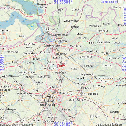
Duffel GPS coordinates[2]
51° 5' 43.944" North, 4° 30' 32.508" East
| Map corner | latitude | longitude |
|---|---|---|
| Upper-left | 51.53501°, | 3.80591° |
| Center: | 51.09554°, | 4.50903° |
| Lower-right: | 50.65185°, | 5.21216° |
| Map W x H: | 98.2×98.2 km | = 61×61mi |
| max Lat: | 51.46791° ⇑20.4% North |
| Duffel: | 51.09554° |
| min Lat: | ⇓79.6% South 49.53771° |
| min Long | Duffel | max Long |
| 2.59368° | 4.50903° | 6.25749° |
| W 46.4%⇐ | ⇒53.6% E |
Elevation
Elevation of Duffel is 5 m = 16 ft, and this is 94.5 m = 310 ft below average elevation for this country.
| Max E: |
582 m = 1909 ft | 97.3% |
| Avg. | 99.5 m = 326 ft | |
| Duffel | 5 m = 16 ft | |
Min E: |
1 m = 3 ft | 2.7% |
See also: Belgium elevation on elevation.city.
Geographical zone
Duffel is located in North temperate zone (between Tropic of Cancer and the Arctic Circle). Distance of this North polar circle is 1719.9 km =1068.7 mi to North.| Distance of | km | miles | from Duffel |
|---|---|---|---|
| North Pole | 4325.8 | 2687.9 | to North |
| Arctic Circle | 1719.9 | 1068.7 | to North |
| Tropic Cancer | 3075.4 | 1911 | to South |
| Equator | 5681.3 | 3530.2 | to South |


Nearby cities:
15 places around Duffel: (largest is in red/bold)
• Aartselaar
9.6 km =6 mi,  296°
296°
• Berlaar
10.7 km =6.6 mi,  76°
76°
• Boechout
7.2 km =4.5 mi,  350°
350°
• Bonheiden
8.5 km =5.3 mi,  161°
161°
• Boom
9.6 km =6 mi,  267°
267°
• Edegem
8.1 km =5 mi,  326°
326°
• Hove
7.1 km =4.4 mi,  337°
337°
• Kontich
5.9 km =3.7 mi,  313°
313°
• Lier
5.8 km =3.6 mi,  47°
47°
• Lint
3.6 km =2.2 mi, 346°
• Mechelen
8.1 km =5 mi,  195°
195°
• Mortsel
8.9 km =5.5 mi, 333°
• Putte
9.8 km =6.1 mi,  118°
118°
• Rumst
6.3 km =3.9 mi,  255°
255°
• Sint-Katelijne-Waver
3.7 km =2.3 mi,  150°
150°
Sources, notices
• [Note1] Compared only with cities in Belgium existing in our database
• [Src1] Map data: © OpenStreetMap contributors (CC-BY-SA)
• [Src2] Other city data from geonames.org with taken over terms of usage.
• [Src3] Geographical zone / Annual Mean Temperature by Robert A. Rohde @ Wikipedia
