Hove geodata
Hove (Flanders) is a populated place; located in Belgium in Europe/Brussels (GMT+2) time zone. With population of 7,968 people, there are 366 cities with bigger population in this country. Compared to other cities in Belgium, 86.1% of cities are located further ↓South; 56% of cities are located further →East and 70% of cities have higher elevation than Hove. Note1
Administrative division(s):
- Level 1: Flanders
- Level 2: Provincie Antwerpen
- Level 3: Arrondissement Antwerpen
- Level 4: Hove


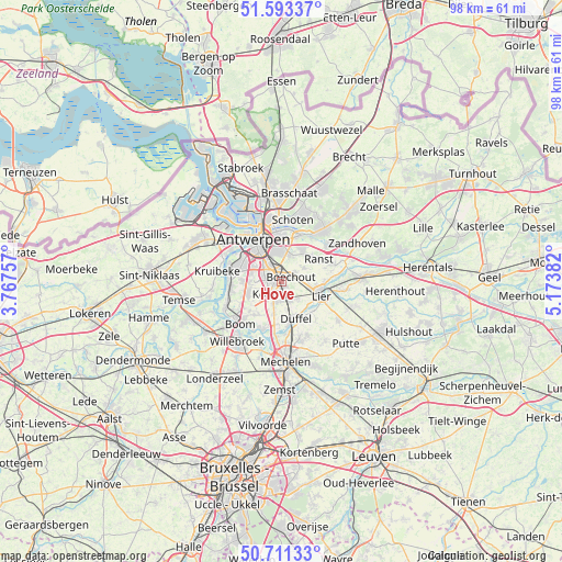
Hove GPS coordinates[2]
51° 9' 16.056" North, 4° 28' 14.52" East
| Map corner | latitude | longitude |
|---|---|---|
| Upper-left | 51.59337°, | 3.76757° |
| Center: | 51.15446°, | 4.4707° |
| Lower-right: | 50.71133°, | 5.17382° |
| Map W x H: | 98.1×98.1 km | = 61×61mi |
| max Lat: | 51.46791° ⇑13.9% North |
| Hove: | 51.15446° |
| min Lat: | ⇓86.1% South 49.53771° |
| min Long | Hove | max Long |
| 2.59368° | 4.4707° | 6.25749° |
| W 44%⇐ | ⇒56% E |
Elevation
Elevation of Hove is 22 m = 72 ft, and this is 77.5 m = 254 ft below average elevation for this country.
| Max E: |
582 m = 1909 ft | 70% |
| Avg. | 99.5 m = 326 ft | |
| Hove | 22 m = 72 ft | |
Min E: |
1 m = 3 ft | 30% |
See also: Belgium elevation on elevation.city.
Geographical zone
Hove is located in North temperate zone (between Tropic of Cancer and the Arctic Circle). Distance of this North polar circle is 1713.3 km =1064.6 mi to North.| Distance of | km | miles | from Hove |
|---|---|---|---|
| North Pole | 4319.2 | 2683.8 | to North |
| Arctic Circle | 1713.3 | 1064.6 | to North |
| Tropic Cancer | 3081.9 | 1915 | to South |
| Equator | 5687.8 | 3534.2 | to South |


Nearby cities:
15 places around Hove: (largest is in red/bold)
• Aartselaar
6.3 km =3.9 mi,  248°
248°
• Antwerpen
8.7 km =5.4 mi,  327°
327°
• Boechout
1.6 km =1 mi,  68°
68°
• Borsbeek
4.8 km =3 mi,  12°
12°
• Deurne
7.4 km =4.6 mi,  357°
357°
• Duffel
7.1 km =4.4 mi,  157°
157°
• Edegem
1.8 km =1.1 mi,  277°
277°
• Kontich
3 km =1.9 mi,  213°
213°
• Lier
7.4 km =4.6 mi,  110°
110°
• Lint
3.5 km =2.2 mi,  149°
149°
• Mortsel
1.9 km =1.2 mi,  315°
315°
• Ranst
7.7 km =4.8 mi,  59°
59°
• Rumst
8.8 km =5.5 mi,  202°
202°
• Wijnegem
8.8 km =5.5 mi,  22°
22°
• Wommelgem
6.6 km =4.1 mi,  32°
32°
Sources, notices
• [Note1] Compared only with cities in Belgium existing in our database
• [Src1] Map data: © OpenStreetMap contributors (CC-BY-SA)
• [Src2] Other city data from geonames.org with taken over terms of usage.
• [Src3] Geographical zone / Annual Mean Temperature by Robert A. Rohde @ Wikipedia
