Troyan geodata
Troyan (Lovech) is a populated place; located in Bulgaria in Europe/Sofia (GMT+3) time zone. With population of 21,162 people, there are 41 cities with bigger population in this country. Compared to other cities in Bulgaria, 52.7% of cities are located further ↓South; 57.3% of cities are located further →East and 69% of cities have lower elevation than Troyan. Note1


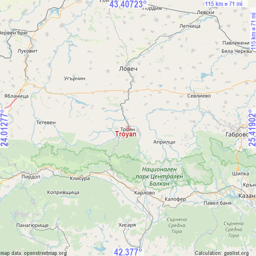
Troyan GPS coordinates[2]
42° 53' 39.372" North, 24° 42' 57.204" East
| Map corner | latitude | longitude |
|---|---|---|
| Upper-left | 43.40723°, | 24.01277° |
| Center: | 42.89427°, | 24.71589° |
| Lower-right: | 42.377°, | 25.41902° |
| Map W x H: | 114.6×114.5 km | = 71.2×71.1mi |
| max Lat: | 44.16214° ⇑47.3% North |
| Troyan: | 42.89427° |
| min Lat: | ⇓52.7% South 41.32715° |
| min Long | Troyan | max Long |
| 22.52139° | 24.71589° | 28.53429° |
| W 42.7%⇐ | ⇒57.3% E |
Elevation
Elevation of Troyan is 389 m = 1276 ft, and this is 72.4 m = 238 ft above average elevation for this country.
| Max E: |
1221 m = 4006 ft | 31% |
| Troyan | 389 m 1276 ft | |
| Avg. | 316.6 m = 1039 ft | |
Min E: |
1 m = 3 ft | 69% |
See also: Bulgaria elevation on elevation.city.
Geographical zone
Troyan is located in North temperate zone (between Tropic of Cancer and the Arctic Circle). Distance of this Northern Tropic circle is 2163.5 km =1344.3 mi to South.| Distance of | km | miles | from Troyan |
|---|---|---|---|
| North Pole | 5237.7 | 3254.6 | to North |
| Arctic Circle | 2631.8 | 1635.3 | to North |
| Tropic Cancer | 2163.5 | 1344.3 | to South |
| Equator | 4769.4 | 2963.6 | to South |


Nearby cities:
15 places around Troyan: (largest is in red/bold)
• Anton
38.8 km =24.1 mi,  245°
245°
• Apriltsi
17.5 km =10.9 mi,  109°
109°
• Asen
47.9 km =29.8 mi,  124°
124°
• Gabrovo
50.4 km =31.3 mi,  92°
92°
• Hisarya
43.9 km =27.3 mi,  181°
181°
• Kalofer
37.8 km =23.5 mi,  144°
144°
• Karlovo
29.8 km =18.5 mi,  166°
166°
• Klisura
30.6 km =19 mi,  225°
225°
• Koprivshtitsa
41.6 km =25.8 mi, 225°
• Lovech
26.6 km =16.5 mi,  0°
0°
• Pirdop
48.5 km =30.1 mi,  243°
243°
• Sevlievo
35.5 km =22.1 mi,  65°
65°
• Suhindol
50.2 km =31.2 mi,  48°
48°
• Teteven
36.7 km =22.8 mi,  273°
273°
• Ugarchin
33.4 km =20.8 mi,  313°
313°
Sources, notices
• [Note1] Compared only with cities in Bulgaria existing in our database
• [Src1] Map data: © OpenStreetMap contributors (CC-BY-SA)
• [Src2] Other city data from geonames.org with taken over terms of usage.
• [Src3] Geographical zone / Annual Mean Temperature by Robert A. Rohde @ Wikipedia
