Pernik geodata
Pernik is a seat of a first-order administrative division; located in Bulgaria in Europe/Sofia (GMT+3) time zone. With population of 82,467 people, there are 10 cities with bigger population in this country. Compared to other cities in Bulgaria, 63% of cities are located further ↑North; 91.3% of cities are located further →East and 90.3% of cities have lower elevation than Pernik. Note1


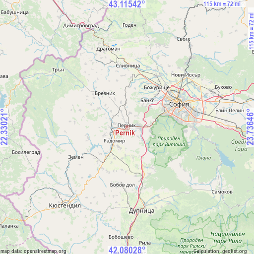
Pernik GPS coordinates[2]
42° 36' 0" North, 23° 1' 59.988" East
| Map corner | latitude | longitude |
|---|---|---|
| Upper-left | 43.11542°, | 22.33021° |
| Center: | 42.6°, | 23.03333° |
| Lower-right: | 42.08028°, | 23.73646° |
| Map W x H: | 115.1×115.1 km | = 71.5×71.5mi |
| max Lat: | 44.16214° ⇑63% North |
| Pernik: | 42.6° |
| min Lat: | ⇓37% South 41.32715° |
| min Long | Pernik | max Long |
| 22.52139° | 23.03333° | 28.53429° |
| W 8.7%⇐ | ⇒91.3% E |
Elevation
Elevation of Pernik is 712 m = 2336 ft, and this is 395.4 m = 1297 ft above average elevation for this country.
| Max E: |
1221 m = 4006 ft | 9.7% |
| Pernik | 712 m 2336 ft | |
| Avg. | 316.6 m = 1039 ft | |
Min E: |
1 m = 3 ft | 90.3% |
See also: Pernik elevation on elevation.city.
Geographical zone
Pernik is located in North temperate zone (between Tropic of Cancer and the Arctic Circle). Distance of this Northern Tropic circle is 2130.8 km =1324 mi to South.| Distance of | km | miles | from Pernik |
|---|---|---|---|
| North Pole | 5270.4 | 3274.9 | to North |
| Arctic Circle | 2664.5 | 1655.6 | to North |
| Tropic Cancer | 2130.8 | 1324 | to South |
| Equator | 4736.7 | 2943.2 | to South |


Nearby cities:
15 places around Pernik: (largest is in red/bold)
• Batanovtsi
6.3 km =3.9 mi,  266°
266°
• Bobov Dol
26.5 km =16.5 mi,  185°
185°
• Bozhurishte
21.5 km =13.4 mi,  39°
39°
• Breznik
18.7 km =11.6 mi,  326°
326°
• Dragoman
36.8 km =22.9 mi,  346°
346°
• Dupnitsa
37.7 km =23.4 mi,  169°
169°
• Kostinbrod
28.4 km =17.6 mi,  31°
31°
• Kyustendil
45 km =28 mi,  218°
218°
• Nevestino
41.1 km =25.5 mi,  201°
201°
• Radomir
8.2 km =5.1 mi, 222°
• Sapareva Banya
40.1 km =24.9 mi,  151°
151°
• Slivnitsa
28 km =17.4 mi,  0°
0°
• Sofia
26.1 km =16.2 mi,  65°
65°
• Tran
40.7 km =25.3 mi,  309°
309°
• Zemen
26.9 km =16.7 mi,  239°
239°
Sources, notices
• [Note1] Compared only with cities in Bulgaria existing in our database
• [Src1] Map data: © OpenStreetMap contributors (CC-BY-SA)
• [Src2] Other city data from geonames.org with taken over terms of usage.
• [Src3] Geographical zone / Annual Mean Temperature by Robert A. Rohde @ Wikipedia
