Razgrad geodata
Razgrad is a seat of a first-order administrative division; located in Bulgaria in Europe/Sofia (GMT+3) time zone. With population of 38,285 people, there are 27 cities with bigger population in this country. Compared to other cities in Bulgaria, 81.3% of cities are located further ↓South; 75% of cities are located further ←West and 56.3% of cities have higher elevation than Razgrad. Note1


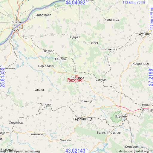
Razgrad GPS coordinates[2]
43° 31' 59.988" North, 26° 31' 0.012" East
| Map corner | latitude | longitude |
|---|---|---|
| Upper-left | 44.04092°, | 25.81355° |
| Center: | 43.53333°, | 26.51667° |
| Lower-right: | 43.02143°, | 27.2198° |
| Map W x H: | 113.4×113.4 km | = 70.5×70.5mi |
| max Lat: | 44.16214° ⇑18.7% North |
| Razgrad: | 43.53333° |
| min Lat: | ⇓81.3% South 41.32715° |
| min Long | Razgrad | max Long |
| 22.52139° | 26.51667° | 28.53429° |
| W 75%⇐ | ⇒25% E |
Elevation
Elevation of Razgrad is 197 m = 646 ft, and this is 119.6 m = 392 ft below average elevation for this country.
| Max E: |
1221 m = 4006 ft | 56.3% |
| Avg. | 316.6 m = 1039 ft | |
| Razgrad | 197 m = 646 ft | |
Min E: |
1 m = 3 ft | 43.7% |
See also: Bulgaria elevation on elevation.city.
Geographical zone
Razgrad is located in North temperate zone (between Tropic of Cancer and the Arctic Circle). Distance of this Northern Tropic circle is 2234.5 km =1388.5 mi to South.| Distance of | km | miles | from Razgrad |
|---|---|---|---|
| North Pole | 5166.6 | 3210.4 | to North |
| Arctic Circle | 2560.7 | 1591.1 | to North |
| Tropic Cancer | 2234.5 | 1388.5 | to South |
| Equator | 4840.5 | 3007.7 | to South |


Nearby cities:
15 places around Razgrad: (largest is in red/bold)
• Gara Hitrino
34.1 km =21.2 mi,  109°
109°
• Isperih
32.6 km =20.3 mi,  51°
51°
• Kubrat
29.3 km =18.2 mi,  357°
357°
• Loznitsa
19.7 km =12.2 mi,  160°
160°
• Medovene
25.9 km =16.1 mi,  0°
0°
• Opaka
29.7 km =18.5 mi,  251°
251°
• Popovo
30.6 km =19 mi,  228°
228°
• Samuil
18.9 km =11.7 mi,  95°
95°
• Senovo
17.7 km =11 mi,  317°
317°
• Targovishte
31.7 km =19.7 mi,  171°
171°
• Tochilari
35.4 km =22 mi,  353°
353°
• Tsar Kaloyan
23.4 km =14.5 mi,  293°
293°
• Venets
33.6 km =20.9 mi,  86°
86°
• Vetovo
27.4 km =17 mi,  312°
312°
• Zavet
28.5 km =17.7 mi,  27°
27°
Sources, notices
• [Note1] Compared only with cities in Bulgaria existing in our database
• [Src1] Map data: © OpenStreetMap contributors (CC-BY-SA)
• [Src2] Other city data from geonames.org with taken over terms of usage.
• [Src3] Geographical zone / Annual Mean Temperature by Robert A. Rohde @ Wikipedia
