Targovishte geodata
Targovishte is a seat of a first-order administrative division; located in Bulgaria in Europe/Sofia (GMT+3) time zone. With population of 37,774 people, there are 28 cities with bigger population in this country. Compared to other cities in Bulgaria, 68% of cities are located further ↓South; 76% of cities are located further ←West and 60.7% of cities have higher elevation than Targovishte. Note1


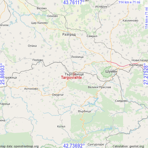
Targovishte GPS coordinates[2]
43° 15' 4.32" North, 26° 34' 19.74" East
| Map corner | latitude | longitude |
|---|---|---|
| Upper-left | 43.76117°, | 25.86903° |
| Center: | 43.2512°, | 26.57215° |
| Lower-right: | 42.73692°, | 27.27528° |
| Map W x H: | 113.9×113.9 km | = 70.8×70.8mi |
| max Lat: | 44.16214° ⇑32% North |
| Targovishte: | 43.2512° |
| min Lat: | ⇓68% South 41.32715° |
| min Long | Targovishte | max Long |
| 22.52139° | 26.57215° | 28.53429° |
| W 76%⇐ | ⇒24% E |
Elevation
Elevation of Targovishte is 186 m = 610 ft, and this is 130.6 m = 428 ft below average elevation for this country.
| Max E: |
1221 m = 4006 ft | 60.7% |
| Avg. | 316.6 m = 1039 ft | |
| Targovishte | 186 m = 610 ft | |
Min E: |
1 m = 3 ft | 39.3% |
See also: Bulgaria elevation on elevation.city.
Geographical zone
Targovishte is located in North temperate zone (between Tropic of Cancer and the Arctic Circle). Distance of this Northern Tropic circle is 2203.2 km =1369 mi to South.| Distance of | km | miles | from Targovishte |
|---|---|---|---|
| North Pole | 5198 | 3229.9 | to North |
| Arctic Circle | 2592.1 | 1610.7 | to North |
| Tropic Cancer | 2203.2 | 1369 | to South |
| Equator | 4809.1 | 2988.2 | to South |


Nearby cities:
15 places around Targovishte: (largest is in red/bold)
• Antonovo
34.7 km =21.6 mi,  251°
251°
• Gara Hitrino
34.4 km =21.4 mi,  53°
53°
• Kotel
42.1 km =26.2 mi,  193°
193°
• Loznitsa
13 km =8.1 mi,  9°
9°
• Omurtag
21 km =13 mi,  216°
216°
• Opaka
39.5 km =24.5 mi,  303°
303°
• Pliska
45.9 km =28.5 mi,  73°
73°
• Popovo
29.5 km =18.3 mi,  291°
291°
• Razgrad
31.7 km =19.7 mi,  351°
351°
• Samuil
32.8 km =20.4 mi,  25°
25°
• Shumen
28.5 km =17.7 mi,  85°
85°
• Smyadovo
41.5 km =25.8 mi,  119°
119°
• Varbitsa
28.4 km =17.6 mi,  169°
169°
• Veliki Preslav
21.9 km =13.6 mi, 115°
• Venets
44.2 km =27.5 mi,  41°
41°
In other languages:
- In Spanish: Tărgovište
- In France: Targovichté
- In German: Targowischte
- In Italian: Tărgovište
- In Russian: Тырговиште
- In Chinese: 特爾戈維什特
Sources, notices
• [Note1] Compared only with cities in Bulgaria existing in our database
• [Src1] Map data: © OpenStreetMap contributors (CC-BY-SA)
• [Src2] Other city data from geonames.org with taken over terms of usage.
• [Src3] Geographical zone / Annual Mean Temperature by Robert A. Rohde @ Wikipedia
