Hayredin geodata
Hayredin (Vratsa) is a seat of a second-order administrative division; located in Bulgaria in Europe/Sofia (GMT+3) time zone. With population of 2,228 people, there are 224 cities with bigger population in this country. Compared to other cities in Bulgaria, 83.7% of cities are located further ↓South; 78.3% of cities are located further →East and 88.3% of cities have higher elevation than Hayredin. Note1


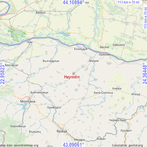
Hayredin GPS coordinates[2]
43° 36' 6.948" North, 23° 39' 40.86" East
| Map corner | latitude | longitude |
|---|---|---|
| Upper-left | 44.10894°, | 22.95823° |
| Center: | 43.60193°, | 23.66135° |
| Lower-right: | 43.09061°, | 24.36448° |
| Map W x H: | 113.2×113.2 km | = 70.3×70.3mi |
| max Lat: | 44.16214° ⇑16.3% North |
| Hayredin: | 43.60193° |
| min Lat: | ⇓83.7% South 41.32715° |
| min Long | Hayredin | max Long |
| 22.52139° | 23.66135° | 28.53429° |
| W 21.7%⇐ | ⇒78.3% E |
Elevation
Elevation of Hayredin is 45 m = 148 ft, and this is 271.6 m = 891 ft below average elevation for this country.
| Max E: |
1221 m = 4006 ft | 88.3% |
| Avg. | 316.6 m = 1039 ft | |
| Hayredin | 45 m = 148 ft | |
Min E: |
1 m = 3 ft | 11.7% |
See also: Bulgaria elevation on elevation.city.
Geographical zone
Hayredin is located in North temperate zone (between Tropic of Cancer and the Arctic Circle). Distance of this Northern Tropic circle is 2242.2 km =1393.2 mi to South.| Distance of | km | miles | from Hayredin |
|---|---|---|---|
| North Pole | 5159 | 3205.7 | to North |
| Arctic Circle | 2553.1 | 1586.4 | to North |
| Tropic Cancer | 2242.2 | 1393.2 | to South |
| Equator | 4848.1 | 3012.5 | to South |


Nearby cities:
15 places around Hayredin: (largest is in red/bold)
• Borovan
20.1 km =12.5 mi,  159°
159°
• Boychinovtsi
29.9 km =18.6 mi,  241°
241°
• Byala Slatina
26.6 km =16.5 mi,  124°
124°
• Knezha
35.8 km =22.2 mi,  108°
108°
• Koynare
47.3 km =29.4 mi,  126°
126°
• Kozloduy
20.2 km =12.6 mi,  13°
13°
• Krivodol
29 km =18 mi,  209°
209°
• Lom
41.9 km =26 mi,  305°
305°
• Medkovets
39.7 km =24.7 mi,  273°
273°
• Mizia
18.1 km =11.2 mi,  58°
58°
• Montana
41 km =25.5 mi, 239°
• Oryahovo
28.3 km =17.6 mi, 58°
• Valchedram
20.1 km =12.5 mi,  300°
300°
• Vratsa
44.3 km =27.5 mi,  190°
190°
• Yakimovo
25 km =15.5 mi,  278°
278°
Sources, notices
• [Note1] Compared only with cities in Bulgaria existing in our database
• [Src1] Map data: © OpenStreetMap contributors (CC-BY-SA)
• [Src2] Other city data from geonames.org with taken over terms of usage.
• [Src3] Geographical zone / Annual Mean Temperature by Robert A. Rohde @ Wikipedia
