Mizia geodata
Mizia (Vratsa) is a seat of a second-order administrative division; located in Bulgaria in Europe/Sofia (GMT+3) time zone. With population of 3,712 people, there are 166 cities with bigger population in this country. Compared to other cities in Bulgaria, 88.3% of cities are located further ↓South; 74.7% of cities are located further →East and 91.7% of cities have higher elevation than Mizia. Note1


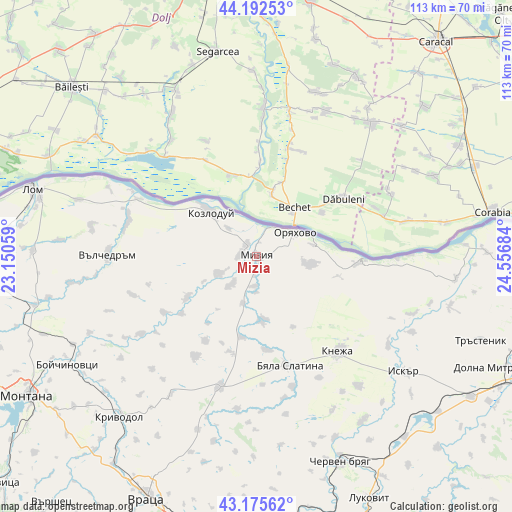
Mizia GPS coordinates[2]
43° 41' 10.428" North, 23° 51' 13.356" East
| Map corner | latitude | longitude |
|---|---|---|
| Upper-left | 44.19253°, | 23.15059° |
| Center: | 43.68623°, | 23.85371° |
| Lower-right: | 43.17562°, | 24.55684° |
| Map W x H: | 113.1×113.1 km | = 70.3×70.3mi |
| max Lat: | 44.16214° ⇑11.7% North |
| Mizia: | 43.68623° |
| min Lat: | ⇓88.3% South 41.32715° |
| min Long | Mizia | max Long |
| 22.52139° | 23.85371° | 28.53429° |
| W 25.3%⇐ | ⇒74.7% E |
Elevation
Elevation of Mizia is 34 m = 112 ft, and this is 282.6 m = 927 ft below average elevation for this country.
| Max E: |
1221 m = 4006 ft | 91.7% |
| Avg. | 316.6 m = 1039 ft | |
| Mizia | 34 m = 112 ft | |
Min E: |
1 m = 3 ft | 8.3% |
See also: Bulgaria elevation on elevation.city.
Geographical zone
Mizia is located in North temperate zone (between Tropic of Cancer and the Arctic Circle). Distance of this Northern Tropic circle is 2251.5 km =1399 mi to South.| Distance of | km | miles | from Mizia |
|---|---|---|---|
| North Pole | 5149.6 | 3199.8 | to North |
| Arctic Circle | 2543.7 | 1580.6 | to North |
| Tropic Cancer | 2251.5 | 1399 | to South |
| Equator | 4857.5 | 3018.3 | to South |


Nearby cities:
15 places around Mizia: (largest is in red/bold)
• Borovan
29.3 km =18.2 mi,  196°
196°
• Boychinovtsi
48 km =29.8 mi,  240°
240°
• Byala Slatina
25.2 km =15.7 mi,  165°
165°
• Cherven Bryag
48.9 km =30.4 mi,  157°
157°
• Hayredin
18.1 km =11.2 mi, 238°
• Iskar
42.4 km =26.3 mi,  128°
128°
• Iskar
48.2 km =30 mi,  92°
92°
• Knezha
27.8 km =17.3 mi,  138°
138°
• Koynare
43.7 km =27.2 mi,  148°
148°
• Kozloduy
14.8 km =9.2 mi,  313°
313°
• Krivodol
45.7 km =28.4 mi,  220°
220°
• Lom
51.8 km =32.2 mi,  286°
286°
• Oryahovo
10.2 km =6.3 mi,  57°
57°
• Valchedram
32.9 km =20.4 mi,  271°
271°
• Yakimovo
40.6 km =25.2 mi,  261°
261°
Sources, notices
• [Note1] Compared only with cities in Bulgaria existing in our database
• [Src1] Map data: © OpenStreetMap contributors (CC-BY-SA)
• [Src2] Other city data from geonames.org with taken over terms of usage.
• [Src3] Geographical zone / Annual Mean Temperature by Robert A. Rohde @ Wikipedia
