São Miguel do Guamá geodata
São Miguel do Guamá (Pará) is a populated place; located in Brazil in America/Belem (GMT-3) time zone. With population of 28,265 people, there are 699 cities with bigger population in this country. Compared to other cities in Brazil, 98.2% of cities are located further ↓South; 61.7% of cities are located further →East and 95.4% of cities have higher elevation than São Miguel do Guamá. Note1


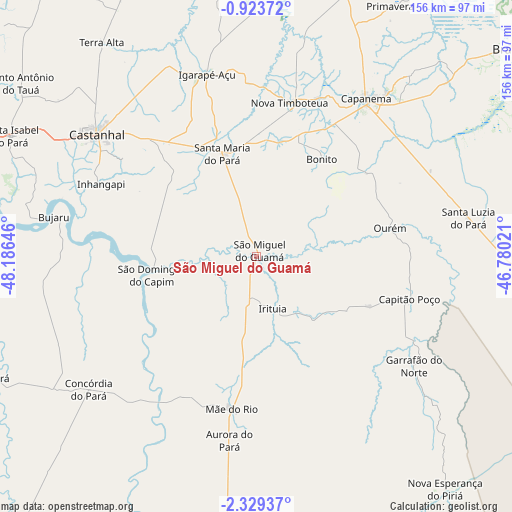
São Miguel do Guamá GPS coordinates[2]
1° 37' 36.012" South, 47° 28' 59.988" West
| Map corner | latitude | longitude |
|---|---|---|
| Upper-left | -0.92372°, | -48.18646° |
| Center: | -1.62667°, | -47.48333° |
| Lower-right: | -2.32937°, | -46.78021° |
| Map W x H: | 156.3×156.3 km | = 97.1×97.1mi |
| max Lat: | 2.81972° ⇑1.8% North |
| São Miguel do Guamá: | -1.62667° |
| min Lat: | ⇓98.2% South -33.69111° |
| min Long | São Miguel do | max Long |
| -72.89583° | -47.48333° | -32.41083° |
| W 38.3%⇐ | ⇒61.7% E |
Elevation
Elevation of São Miguel do Guamá is 9 m = 30 ft, and this is 371.9 m = 1220 ft below average elevation for this country.
| Max E: |
1603 m = 5259 ft | 95.4% |
| Avg. | 380.9 m = 1250 ft | |
| São Miguel do Guamá | 9 m = 30 ft | |
Min E: |
0 m = 0 ft | 4.6% |
See also: Brazil elevation on elevation.city.
Geographical zone
São Miguel do Guamá is located in South Torrid zone (between Equator and Tropic of Capricorn). Distance of Equator is 180.9 km =112.4 mi to North.| Distance of | km | miles | from São Miguel do Guamá |
|---|---|---|---|
| Equator | 180.9 | 112.4 | to North |
| Tropic Capricorn | 2425.1 | 1506.9 | to South |
| Antarctic Circle | 7220.3 | 4486.5 | to South |
| South Pole | 9826.2 | 6105.7 | to South |


Nearby cities:
15 places around São Miguel do Guamá: (largest is in red/bold)
• Acará
87.6 km =54.4 mi,  244°
244°
• Ananindeua
103 km =64 mi,  286°
286°
• Benevides
89.6 km =55.7 mi, 289°
• Bragança
102.1 km =63.4 mi,  51°
51°
• Bujaru
63.6 km =39.5 mi,  281°
281°
• Capanema
58.5 km =36.4 mi,  35°
35°
• Capitão Poço
49 km =30.4 mi,  105°
105°
• Castanhal
61.6 km =38.3 mi,  306°
306°
• Igarapé Açu
57.4 km =35.7 mi,  344°
344°
• Irituia
16.8 km =10.4 mi,  162°
162°
• Maracanã
95.7 km =59.5 mi,  1°
1°
• Ourém
41.8 km =26 mi,  78°
78°
• Santa Maria do Pará
32.4 km =20.1 mi, 341°
• Santo Antônio do Tauá
89.1 km =55.4 mi, 306°
• São João de Pirabas
100.7 km =62.6 mi,  19°
19°
Sources, notices
• [Note1] Compared only with cities in Brazil existing in our database
• [Src1] Map data: © OpenStreetMap contributors (CC-BY-SA)
• [Src2] Other city data from geonames.org with taken over terms of usage.
• [Src3] Geographical zone / Annual Mean Temperature by Robert A. Rohde @ Wikipedia
