Maracanã geodata
Maracanã (Pará) is a populated place; located in Brazil in America/Belem (GMT-3) time zone. With population of 12,682 people, there are 1399 cities with bigger population in this country. Compared to other cities in Brazil, 99.4% of cities are located further ↓South; 61.2% of cities are located further →East and 88.3% of cities have higher elevation than Maracanã. Note1


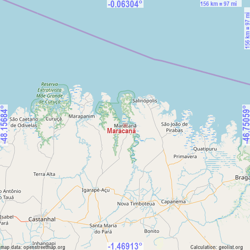
Maracanã GPS coordinates[2]
0° 45' 58.104" South, 47° 27' 13.356" West
| Map corner | latitude | longitude |
|---|---|---|
| Upper-left | -0.06304°, | -48.15684° |
| Center: | -0.76614°, | -47.45371° |
| Lower-right: | -1.46913°, | -46.75059° |
| Map W x H: | 156.3×156.3 km | = 97.1×97.1mi |
| max Lat: | 2.81972° ⇑0.6% North |
| Maracanã: | -0.76614° |
| min Lat: | ⇓99.4% South -33.69111° |
| min Long | Maracanã | max Long |
| -72.89583° | -47.45371° | -32.41083° |
| W 38.8%⇐ | ⇒61.2% E |
Elevation
Elevation of Maracanã is 21 m = 69 ft, and this is 359.9 m = 1181 ft below average elevation for this country.
| Max E: |
1603 m = 5259 ft | 88.3% |
| Avg. | 380.9 m = 1250 ft | |
| Maracanã | 21 m = 69 ft | |
Min E: |
0 m = 0 ft | 11.7% |
See also: Brazil elevation on elevation.city.
Geographical zone
Maracanã is located in South Torrid zone (between Equator and Tropic of Capricorn). Distance of Equator is 85.2 km =52.9 mi to North.| Distance of | km | miles | from Maracanã |
|---|---|---|---|
| Equator | 85.2 | 52.9 | to North |
| Tropic Capricorn | 2520.7 | 1566.3 | to South |
| Antarctic Circle | 7316 | 4546 | to South |
| South Pole | 9921.9 | 6165.2 | to South |


Nearby cities:
15 places around Maracanã: (largest is in red/bold)
• Augusto Corrêa
95.4 km =59.3 mi,  107°
107°
• Bragança
82.9 km =51.5 mi, 112°
• Capanema
56.6 km =35.2 mi,  147°
147°
• Castanhal
78.8 km =49 mi,  221°
221°
• Curuçá
44 km =27.3 mi,  275°
275°
• Igarapé Açu
44.4 km =27.6 mi,  204°
204°
• Marapanim
27.9 km =17.3 mi, 281°
• Ourém
95.2 km =59.2 mi,  156°
156°
• Salinópolis
20.1 km =12.5 mi,  32°
32°
• Santa Maria do Pará
66.3 km =41.2 mi,  191°
191°
• Santo Antônio do Tauá
86.5 km =53.7 mi,  240°
240°
• São Caetano de Odivelas
63 km =39.1 mi,  271°
271°
• São João de Pirabas
30.8 km =19.1 mi,  91°
91°
• São Miguel do Guamá
95.7 km =59.5 mi,  181°
181°
• Vigia
77.2 km =48 mi,  262°
262°
Sources, notices
• [Note1] Compared only with cities in Brazil existing in our database
• [Src1] Map data: © OpenStreetMap contributors (CC-BY-SA)
• [Src2] Other city data from geonames.org with taken over terms of usage.
• [Src3] Geographical zone / Annual Mean Temperature by Robert A. Rohde @ Wikipedia
