Bragança geodata
Bragança (Pará) is a populated place; located in Brazil in America/Belem (GMT-3) time zone. With population of 57,163 people, there are 383 cities with bigger population in this country. Compared to other cities in Brazil, 99.1% of cities are located further ↓South; 56.7% of cities are located further →East and 90.9% of cities have higher elevation than Bragança. Note1


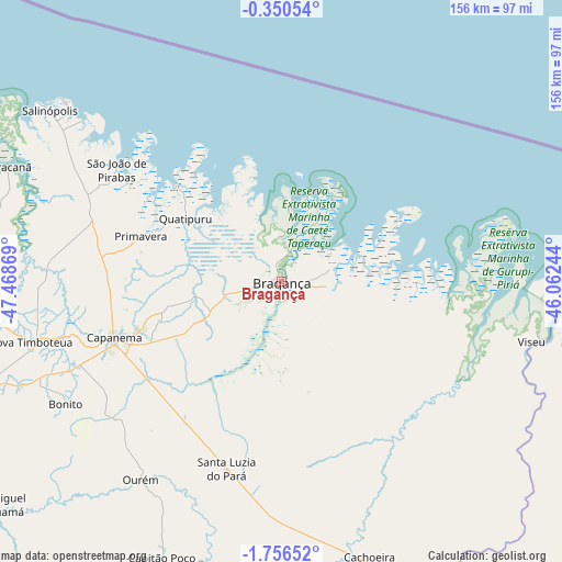
Bragança GPS coordinates[2]
1° 3' 12.996" South, 46° 45' 56.016" West
| Map corner | latitude | longitude |
|---|---|---|
| Upper-left | -0.35054°, | -47.46869° |
| Center: | -1.05361°, | -46.76556° |
| Lower-right: | -1.75652°, | -46.06244° |
| Map W x H: | 156.3×156.3 km | = 97.1×97.1mi |
| max Lat: | 2.81972° ⇑0.9% North |
| Bragança: | -1.05361° |
| min Lat: | ⇓99.1% South -33.69111° |
| min Long | Bragança | max Long |
| -72.89583° | -46.76556° | -32.41083° |
| W 43.3%⇐ | ⇒56.7% E |
Elevation
Elevation of Bragança is 16 m = 52 ft, and this is 364.9 m = 1197 ft below average elevation for this country.
| Max E: |
1603 m = 5259 ft | 90.9% |
| Avg. | 380.9 m = 1250 ft | |
| Bragança | 16 m = 52 ft | |
Min E: |
0 m = 0 ft | 9.1% |
See also: Bragança elevation on elevation.city.
Geographical zone
Bragança is located in South Torrid zone (between Equator and Tropic of Capricorn). Distance of Equator is 117.2 km =72.8 mi to North.| Distance of | km | miles | from Bragança |
|---|---|---|---|
| Equator | 117.2 | 72.8 | to North |
| Tropic Capricorn | 2488.8 | 1546.5 | to South |
| Antarctic Circle | 7284 | 4526.1 | to South |
| South Pole | 9889.9 | 6145.3 | to South |


Nearby cities:
15 places around Bragança: (largest is in red/bold)
• Augusto Corrêa
14.9 km =9.3 mi,  76°
76°
• Capanema
48.8 km =30.3 mi,  251°
251°
• Capitão Poço
83.7 km =52 mi,  202°
202°
• Carutapera
84.4 km =52.4 mi,  100°
100°
• Cândido Mendes
124.5 km =77.4 mi,  110°
110°
• Igarapé Açu
95.4 km =59.3 mi,  264°
264°
• Irituia
109.3 km =67.9 mi,  223°
223°
• Maracanã
82.9 km =51.5 mi,  292°
292°
• Marapanim
110.4 km =68.6 mi, 289°
• Ourém
67.6 km =42 mi,  214°
214°
• Salinópolis
81.9 km =50.9 mi,  306°
306°
• Santa Maria do Pará
95.9 km =59.6 mi, 249°
• São João de Pirabas
55.3 km =34.4 mi,  304°
304°
• São Miguel do Guamá
102.1 km =63.4 mi,  231°
231°
• Viseu
71.3 km =44.3 mi, 102°
Sources, notices
• [Note1] Compared only with cities in Brazil existing in our database
• [Src1] Map data: © OpenStreetMap contributors (CC-BY-SA)
• [Src2] Other city data from geonames.org with taken over terms of usage.
• [Src3] Geographical zone / Annual Mean Temperature by Robert A. Rohde @ Wikipedia
