Rio Largo geodata
Rio Largo (Alagoas) is a populated place; located in Brazil in America/Maceio (GMT-3) time zone. With population of 63,387 people, there are 354 cities with bigger population in this country. Compared to other cities in Brazil, 69.5% of cities are located further ↓South; 93.4% of cities are located further ←West and 72.7% of cities have higher elevation than Rio Largo. Note1


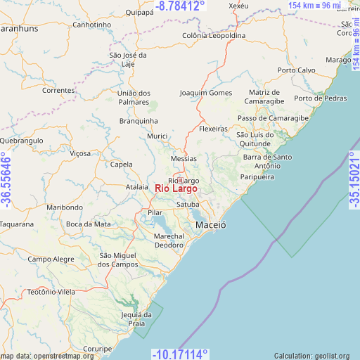
Rio Largo GPS coordinates[2]
9° 28' 41.988" South, 35° 51' 11.988" West
| Map corner | latitude | longitude |
|---|---|---|
| Upper-left | -8.78412°, | -36.55646° |
| Center: | -9.47833°, | -35.85333° |
| Lower-right: | -10.17114°, | -35.15021° |
| Map W x H: | 154.2×154.2 km | = 95.8×95.8mi |
| max Lat: | 2.81972° ⇑30.5% North |
| Rio Largo: | -9.47833° |
| min Lat: | ⇓69.5% South -33.69111° |
| min Long | Rio Largo | max Long |
| -72.89583° | -35.85333° | -32.41083° |
| W 93.4%⇐ | ⇒6.6% E |
Elevation
Elevation of Rio Largo is 97 m = 318 ft, and this is 283.9 m = 931 ft below average elevation for this country.
| Max E: |
1603 m = 5259 ft | 72.7% |
| Avg. | 380.9 m = 1250 ft | |
| Rio Largo | 97 m = 318 ft | |
Min E: |
0 m = 0 ft | 27.3% |
See also: Rio Largo elevation on elevation.city.
Geographical zone
Rio Largo is located in South Torrid zone (between Equator and Tropic of Capricorn). Distance of Equator is 1053.9 km =654.9 mi to North.| Distance of | km | miles | from Rio Largo |
|---|---|---|---|
| Equator | 1053.9 | 654.9 | to North |
| Tropic Capricorn | 1552 | 964.4 | to South |
| Antarctic Circle | 6347.3 | 3944 | to South |
| South Pole | 8953.2 | 5563.3 | to South |


Nearby cities:
15 places around Rio Largo: (largest is in red/bold)
• Atalaia
18.8 km =11.7 mi,  261°
261°
• Barra de Santo Antônio
38.8 km =24.1 mi,  77°
77°
• Capela
25.4 km =15.8 mi,  288°
288°
• Flexeiras
32.2 km =20 mi,  14°
14°
• Maceió
24.5 km =15.2 mi,  148°
148°
• Marechal Deodoro
26.2 km =16.3 mi,  190°
190°
• Matriz de Camaragibe
50.5 km =31.4 mi,  44°
44°
• Messias
10.6 km =6.6 mi, 6°
• Murici
21.5 km =13.4 mi,  332°
332°
• Pilar
17.4 km =10.8 mi,  220°
220°
• Satuba
10 km =6.2 mi,  161°
161°
• São Luís do Quitunde
36.7 km =22.8 mi,  60°
60°
• São Miguel dos Campos
42.7 km =26.5 mi, 218°
• União dos Palmares
40.2 km =25 mi, 330°
• Viçosa
44.1 km =27.4 mi, 285°
Sources, notices
• [Note1] Compared only with cities in Brazil existing in our database
• [Src1] Map data: © OpenStreetMap contributors (CC-BY-SA)
• [Src2] Other city data from geonames.org with taken over terms of usage.
• [Src3] Geographical zone / Annual Mean Temperature by Robert A. Rohde @ Wikipedia
