Capela geodata
Capela (Alagoas) is a populated place; located in Brazil in America/Maceio (GMT-3) time zone. With population of 12,520 people, there are 1420 cities with bigger population in this country. Compared to other cities in Brazil, 69.6% of cities are located further ↓South; 92.3% of cities are located further ←West and 74.3% of cities have higher elevation than Capela. Note1


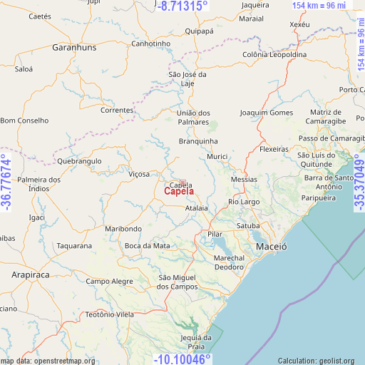
Capela GPS coordinates[2]
9° 24' 27" South, 36° 4' 24.996" West
| Map corner | latitude | longitude |
|---|---|---|
| Upper-left | -8.71315°, | -36.77674° |
| Center: | -9.4075°, | -36.07361° |
| Lower-right: | -10.10046°, | -35.37049° |
| Map W x H: | 154.3×154.3 km | = 95.9×95.9mi |
| max Lat: | 2.81972° ⇑30.4% North |
| Capela: | -9.4075° |
| min Lat: | ⇓69.6% South -33.69111° |
| min Long | Capela | max Long |
| -72.89583° | -36.07361° | -32.41083° |
| W 92.3%⇐ | ⇒7.7% E |
Elevation
Elevation of Capela is 87 m = 285 ft, and this is 293.9 m = 964 ft below average elevation for this country.
| Max E: |
1603 m = 5259 ft | 74.3% |
| Avg. | 380.9 m = 1250 ft | |
| Capela | 87 m = 285 ft | |
Min E: |
0 m = 0 ft | 25.7% |
See also: Brazil elevation on elevation.city.
Geographical zone
Capela is located in South Torrid zone (between Equator and Tropic of Capricorn). Distance of Equator is 1046 km =650 mi to North.| Distance of | km | miles | from Capela |
|---|---|---|---|
| Equator | 1046 | 650 | to North |
| Tropic Capricorn | 1559.9 | 969.3 | to South |
| Antarctic Circle | 6355.2 | 3948.9 | to South |
| South Pole | 8961 | 5568.1 | to South |


Nearby cities:
15 places around Capela: (largest is in red/bold)
• Anadia
39.8 km =24.7 mi,  219°
219°
• Atalaia
11.9 km =7.4 mi,  152°
152°
• Flexeiras
39.7 km =24.7 mi,  53°
53°
• Marechal Deodoro
38.9 km =24.2 mi, 149°
• Maribondo
31.6 km =19.6 mi,  233°
233°
• Messias
25.6 km =15.9 mi,  83°
83°
• Murici
18.2 km =11.3 mi, 51°
• Pilar
24.7 km =15.3 mi, 148°
• Rio Largo
25.4 km =15.8 mi,  108°
108°
• Santana do Mundaú
31.2 km =19.4 mi,  328°
328°
• Satuba
32.4 km =20.1 mi,  122°
122°
• São José da Laje
44.3 km =27.5 mi,  2°
2°
• São Miguel dos Campos
41.6 km =25.8 mi,  183°
183°
• União dos Palmares
27.6 km =17.1 mi,  9°
9°
• Viçosa
18.8 km =11.7 mi,  282°
282°
Sources, notices
• [Note1] Compared only with cities in Brazil existing in our database
• [Src1] Map data: © OpenStreetMap contributors (CC-BY-SA)
• [Src2] Other city data from geonames.org with taken over terms of usage.
• [Src3] Geographical zone / Annual Mean Temperature by Robert A. Rohde @ Wikipedia
