João Alfredo geodata
João Alfredo (Pernambuco) is a populated place; located in Brazil in America/Recife (GMT-3) time zone. With population of 11,334 people, there are 1535 cities with bigger population in this country. Compared to other cities in Brazil, 75.8% of cities are located further ↓South; 95.3% of cities are located further ←West and 50.5% of cities have higher elevation than João Alfredo. Note1


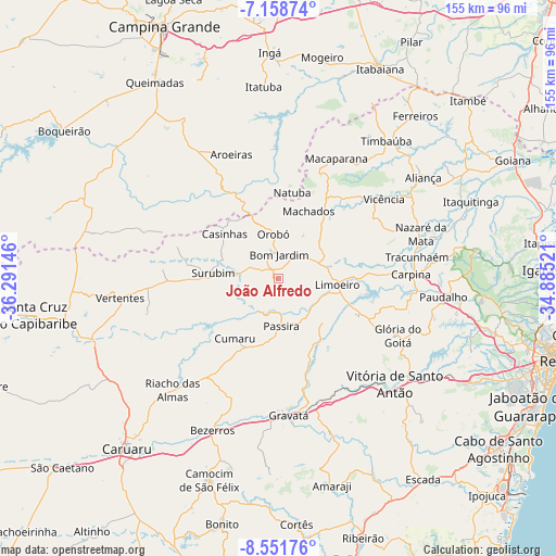
João Alfredo GPS coordinates[2]
7° 51' 20.988" South, 35° 35' 17.988" West
| Map corner | latitude | longitude |
|---|---|---|
| Upper-left | -7.15874°, | -36.29146° |
| Center: | -7.85583°, | -35.58833° |
| Lower-right: | -8.55176°, | -34.88521° |
| Map W x H: | 154.9×154.9 km | = 96.3×96.3mi |
| max Lat: | 2.81972° ⇑24.2% North |
| João Alfredo: | -7.85583° |
| min Lat: | ⇓75.8% South -33.69111° |
| min Long | João Alfredo | max Long |
| -72.89583° | -35.58833° | -32.41083° |
| W 95.3%⇐ | ⇒4.7% E |
Elevation
Elevation of João Alfredo is 345 m = 1132 ft, and this is 35.9 m = 118 ft below average elevation for this country.
| Max E: |
1603 m = 5259 ft | 50.5% |
| Avg. | 380.9 m = 1250 ft | |
| João Alfredo | 345 m = 1132 ft | |
Min E: |
0 m = 0 ft | 49.5% |
See also: Brazil elevation on elevation.city.
Geographical zone
João Alfredo is located in South Torrid zone (between Equator and Tropic of Capricorn). Distance of Equator is 873.5 km =542.8 mi to North.| Distance of | km | miles | from João Alfredo |
|---|---|---|---|
| Equator | 873.5 | 542.8 | to North |
| Tropic Capricorn | 1732.4 | 1076.5 | to South |
| Antarctic Circle | 6527.7 | 4056.1 | to South |
| South Pole | 9133.6 | 5675.4 | to South |


Nearby cities:
15 places around João Alfredo: (largest is in red/bold)
• Aroeiras
36.9 km =22.9 mi,  339°
339°
• Bom Jardim
6.7 km =4.2 mi,  1°
1°
• Carpina
36.8 km =22.9 mi,  89°
89°
• Cumaru
20.6 km =12.8 mi,  215°
215°
• Feira Nova
24.3 km =15.1 mi,  115°
115°
• Glória do Goitá
36.4 km =22.6 mi, 116°
• Lagoa do Itaenga
34 km =21.1 mi,  105°
105°
• Limoeiro
15.3 km =9.5 mi,  97°
97°
• Macaparana
36.6 km =22.7 mi,  23°
23°
• Natuba
24.2 km =15 mi,  10°
10°
• Orobó
12.4 km =7.7 mi,  352°
352°
• Passira
15.5 km =9.6 mi,  176°
176°
• Surubim
18.5 km =11.5 mi,  277°
277°
• Umbuzeiro
19.7 km =12.2 mi, 335°
• Vicência
36.3 km =22.6 mi,  52°
52°
Sources, notices
• [Note1] Compared only with cities in Brazil existing in our database
• [Src1] Map data: © OpenStreetMap contributors (CC-BY-SA)
• [Src2] Other city data from geonames.org with taken over terms of usage.
• [Src3] Geographical zone / Annual Mean Temperature by Robert A. Rohde @ Wikipedia
