Curuçá geodata
Curuçá (Pará) is a populated place; located in Brazil in America/Belem (GMT-3) time zone. With population of 10,843 people, there are 1578 cities with bigger population in this country. Compared to other cities in Brazil, 99.5% of cities are located further ↓South; 63.8% of cities are located further →East and 91.4% of cities have higher elevation than Curuçá. Note1


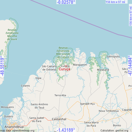
Curuçá GPS coordinates[2]
0° 43' 44.004" South, 47° 50' 53.016" West
| Map corner | latitude | longitude |
|---|---|---|
| Upper-left | -0.02578°, | -48.55119° |
| Center: | -0.72889°, | -47.84806° |
| Lower-right: | -1.43189°, | -47.14494° |
| Map W x H: | 156.3×156.3 km | = 97.1×97.1mi |
| max Lat: | 2.81972° ⇑0.5% North |
| Curuçá: | -0.72889° |
| min Lat: | ⇓99.5% South -33.69111° |
| min Long | Curuçá | max Long |
| -72.89583° | -47.84806° | -32.41083° |
| W 36.2%⇐ | ⇒63.8% E |
Elevation
Elevation of Curuçá is 15 m = 49 ft, and this is 365.9 m = 1200 ft below average elevation for this country.
| Max E: |
1603 m = 5259 ft | 91.4% |
| Avg. | 380.9 m = 1250 ft | |
| Curuçá | 15 m = 49 ft | |
Min E: |
0 m = 0 ft | 8.6% |
See also: Brazil elevation on elevation.city.
Geographical zone
Curuçá is located in South Torrid zone (between Equator and Tropic of Capricorn). Distance of Equator is 81 km =50.3 mi to North.| Distance of | km | miles | from Curuçá |
|---|---|---|---|
| Equator | 81 | 50.3 | to North |
| Tropic Capricorn | 2524.9 | 1568.9 | to South |
| Antarctic Circle | 7320.1 | 4548.5 | to South |
| South Pole | 9926 | 6167.7 | to South |


Nearby cities:
15 places around Curuçá: (largest is in red/bold)
• Ananindeua
91.7 km =57 mi,  219°
219°
• Benevides
83 km =51.6 mi,  212°
212°
• Bujaru
90.1 km =56 mi,  194°
194°
• Capanema
90.5 km =56.2 mi,  124°
124°
• Castanhal
63.4 km =39.4 mi, 187°
• Igarapé Açu
51.2 km =31.8 mi,  150°
150°
• Maracanã
44 km =27.3 mi,  95°
95°
• Marapanim
16.5 km =10.3 mi,  85°
85°
• Salinópolis
56.2 km =34.9 mi,  76°
76°
• Santa Maria do Pará
75.4 km =46.9 mi,  156°
156°
• Santo Antônio do Tauá
56.5 km =35.1 mi, 213°
• Soure
75.1 km =46.7 mi,  271°
271°
• São Caetano de Odivelas
19.3 km =12 mi,  262°
262°
• São João de Pirabas
74.8 km =46.5 mi, 93°
• Vigia
35.7 km =22.2 mi,  246°
246°
Sources, notices
• [Note1] Compared only with cities in Brazil existing in our database
• [Src1] Map data: © OpenStreetMap contributors (CC-BY-SA)
• [Src2] Other city data from geonames.org with taken over terms of usage.
• [Src3] Geographical zone / Annual Mean Temperature by Robert A. Rohde @ Wikipedia
