Chã Grande geodata
Chã Grande (Pernambuco) is a populated place; located in Brazil in America/Recife (GMT-3) time zone. With population of 17,112 people, there are 1090 cities with bigger population in this country. Compared to other cities in Brazil, 74% of cities are located further ↓South; 96.2% of cities are located further ←West and 59.8% of cities have lower elevation than Chã Grande. Note1


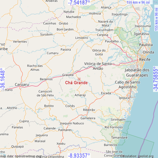
Chã Grande GPS coordinates[2]
8° 14' 17.988" South, 35° 27' 42.012" West
| Map corner | latitude | longitude |
|---|---|---|
| Upper-left | -7.54187°, | -36.1648° |
| Center: | -8.23833°, | -35.46167° |
| Lower-right: | -8.93357°, | -34.75855° |
| Map W x H: | 154.7×154.7 km | = 96.1×96.1mi |
| max Lat: | 2.81972° ⇑26% North |
| Chã Grande: | -8.23833° |
| min Lat: | ⇓74% South -33.69111° |
| min Long | Chã Grande | max Long |
| -72.89583° | -35.46167° | -32.41083° |
| W 96.2%⇐ | ⇒3.8% E |
Elevation
Elevation of Chã Grande is 471 m = 1545 ft, and this is 90.1 m = 296 ft above average elevation for this country.
| Max E: |
1603 m = 5259 ft | 40.2% |
| Chã Grande | 471 m 1545 ft | |
| Avg. | 380.9 m = 1250 ft | |
Min E: |
0 m = 0 ft | 59.8% |
See also: Brazil elevation on elevation.city.
Geographical zone
Chã Grande is located in South Torrid zone (between Equator and Tropic of Capricorn). Distance of Equator is 916 km =569.2 mi to North.| Distance of | km | miles | from Chã Grande |
|---|---|---|---|
| Equator | 916 | 569.2 | to North |
| Tropic Capricorn | 1689.9 | 1050.1 | to South |
| Antarctic Circle | 6485.2 | 4029.7 | to South |
| South Pole | 9091 | 5648.9 | to South |


Nearby cities:
15 places around Chã Grande: (largest is in red/bold)
• Amaraji
16.1 km =10 mi,  176°
176°
• Bezerros
36.9 km =22.9 mi,  270°
270°
• Bonito
39.1 km =24.3 mi,  228°
228°
• Camocim de São Félix
35.6 km =22.1 mi,  247°
247°
• Cumaru
36.6 km =22.7 mi,  314°
314°
• Escada
29.4 km =18.3 mi,  117°
117°
• Feira Nova
32.9 km =20.4 mi,  14°
14°
• Glória do Goitá
32.2 km =20 mi,  35°
35°
• Gravatá
12.1 km =7.5 mi,  290°
290°
• Guabiraba
30 km =18.6 mi, 228°
• Lagoa do Itaenga
38.5 km =23.9 mi,  29°
29°
• Passira
30.1 km =18.7 mi,  334°
334°
• Pombos
13 km =8.1 mi, 33°
• Ribeirão
32.1 km =19.9 mi,  163°
163°
• Vitória de Santo Antão
23 km =14.3 mi,  54°
54°
Sources, notices
• [Note1] Compared only with cities in Brazil existing in our database
• [Src1] Map data: © OpenStreetMap contributors (CC-BY-SA)
• [Src2] Other city data from geonames.org with taken over terms of usage.
• [Src3] Geographical zone / Annual Mean Temperature by Robert A. Rohde @ Wikipedia
