Escada geodata
Escada (Pernambuco) is a populated place; located in Brazil in America/Recife (GMT-3) time zone. With population of 48,083 people, there are 445 cities with bigger population in this country. Compared to other cities in Brazil, 73.6% of cities are located further ↓South; 97.9% of cities are located further ←West and 70.8% of cities have higher elevation than Escada. Note1


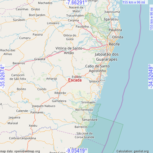
Escada GPS coordinates[2]
8° 21' 33.012" South, 35° 13' 24.996" West
| Map corner | latitude | longitude |
|---|---|---|
| Upper-left | -7.66291°, | -35.92674° |
| Center: | -8.35917°, | -35.22361° |
| Lower-right: | -9.05419°, | -34.52049° |
| Map W x H: | 154.7×154.7 km | = 96.1×96.1mi |
| max Lat: | 2.81972° ⇑26.4% North |
| Escada: | -8.35917° |
| min Lat: | ⇓73.6% South -33.69111° |
| min Long | Escada | max Long |
| -72.89583° | -35.22361° | -32.41083° |
| W 97.9%⇐ | ⇒2.1% E |
Elevation
Elevation of Escada is 117 m = 384 ft, and this is 263.9 m = 866 ft below average elevation for this country.
| Max E: |
1603 m = 5259 ft | 70.8% |
| Avg. | 380.9 m = 1250 ft | |
| Escada | 117 m = 384 ft | |
Min E: |
0 m = 0 ft | 29.2% |
See also: Escada elevation on elevation.city.
Geographical zone
Escada is located in South Torrid zone (between Equator and Tropic of Capricorn). Distance of Equator is 929.5 km =577.6 mi to North.| Distance of | km | miles | from Escada |
|---|---|---|---|
| Equator | 929.5 | 577.6 | to North |
| Tropic Capricorn | 1676.5 | 1041.7 | to South |
| Antarctic Circle | 6471.7 | 4021.3 | to South |
| South Pole | 9077.6 | 5640.6 | to South |


Nearby cities:
15 places around Escada: (largest is in red/bold)
• Amaraji
25.3 km =15.7 mi,  263°
263°
• Cabo
22.6 km =14 mi,  68°
68°
• Chã Grande
29.4 km =18.3 mi,  297°
297°
• Gameleira
30.8 km =19.1 mi,  215°
215°
• Glória do Goitá
40.5 km =25.2 mi,  349°
349°
• Gravatá
41.4 km =25.7 mi, 295°
• Ipojuca
18.1 km =11.2 mi,  104°
104°
• Jaboatão
31.5 km =19.6 mi,  50°
50°
• Jaboatão dos Guararapes
35.8 km =22.2 mi,  39°
39°
• Moreno
30.4 km =18.9 mi,  28°
28°
• Pombos
30.7 km =19.1 mi,  321°
321°
• Ribeirão
24.2 km =15 mi, 224°
• Rio Formoso
35.1 km =21.8 mi,  169°
169°
• Sirinhaém
28.3 km =17.6 mi,  155°
155°
• Vitória de Santo Antão
27.8 km =17.3 mi,  344°
344°
Sources, notices
• [Note1] Compared only with cities in Brazil existing in our database
• [Src1] Map data: © OpenStreetMap contributors (CC-BY-SA)
• [Src2] Other city data from geonames.org with taken over terms of usage.
• [Src3] Geographical zone / Annual Mean Temperature by Robert A. Rohde @ Wikipedia
