Cândido Mendes geodata
Cândido Mendes (Maranhão) is a populated place; located in Brazil in America/Fortaleza (GMT-3) time zone. With population of 8,613 people, there are 1746 cities with bigger population in this country. Compared to other cities in Brazil, 98.6% of cities are located further ↓South; 51.7% of cities are located further →East and 98.3% of cities have higher elevation than Cândido Mendes. Note1


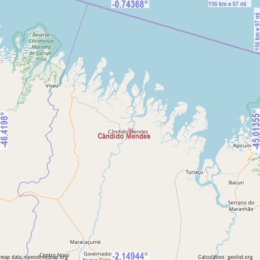
Cândido Mendes GPS coordinates[2]
1° 26' 48.012" South, 45° 43' 0.012" West
| Map corner | latitude | longitude |
|---|---|---|
| Upper-left | -0.74368°, | -46.4198° |
| Center: | -1.44667°, | -45.71667° |
| Lower-right: | -2.14944°, | -45.01355° |
| Map W x H: | 156.3×156.3 km | = 97.1×97.1mi |
| max Lat: | 2.81972° ⇑1.4% North |
| Cândido Mendes: | -1.44667° |
| min Lat: | ⇓98.6% South -33.69111° |
| min Long | Cândido Mendes | max Long |
| -72.89583° | -45.71667° | -32.41083° |
| W 48.3%⇐ | ⇒51.7% E |
Elevation
Elevation of Cândido Mendes is 6 m = 20 ft, and this is 374.9 m = 1230 ft below average elevation for this country.
| Max E: |
1603 m = 5259 ft | 98.3% |
| Avg. | 380.9 m = 1250 ft | |
| Cândido Mendes | 6 m = 20 ft | |
Min E: |
0 m = 0 ft | 1.7% |
See also: Brazil elevation on elevation.city.
Geographical zone
Cândido Mendes is located in South Torrid zone (between Equator and Tropic of Capricorn). Distance of Equator is 160.9 km =100 mi to North.| Distance of | km | miles | from Cândido Mendes |
|---|---|---|---|
| Equator | 160.9 | 100 | to North |
| Tropic Capricorn | 2445.1 | 1519.3 | to South |
| Antarctic Circle | 7240.3 | 4498.9 | to South |
| South Pole | 9846.2 | 6118.1 | to South |


Nearby cities:
15 places around Cândido Mendes: (largest is in red/bold)
• Araguanã
166.9 km =103.7 mi,  177°
177°
• Augusto Corrêa
112.5 km =69.9 mi,  294°
294°
• Bequimão
152.3 km =94.6 mi,  137°
137°
• Bragança
124.5 km =77.4 mi, 290°
• Capanema
165.1 km =102.6 mi,  279°
279°
• Capitão Poço
152.9 km =95 mi,  257°
257°
• Carutapera
43.8 km =27.2 mi,  309°
309°
• Cururupu
103.4 km =64.2 mi,  114°
114°
• Maracaçumé
71.6 km =44.5 mi,  202°
202°
• Nova Olina do Marnhao
155.2 km =96.4 mi, 179°
• Ourém
155.8 km =96.8 mi,  265°
265°
• Pinheiro
138.7 km =86.2 mi,  149°
149°
• Santa Helena
98.8 km =61.4 mi, 152°
• Turiaçu
45.3 km =28.1 mi,  122°
122°
• Viseu
54.7 km =34 mi,  300°
300°
Sources, notices
• [Note1] Compared only with cities in Brazil existing in our database
• [Src1] Map data: © OpenStreetMap contributors (CC-BY-SA)
• [Src2] Other city data from geonames.org with taken over terms of usage.
• [Src3] Geographical zone / Annual Mean Temperature by Robert A. Rohde @ Wikipedia
