Tanguá geodata
Tanguá (Rio de Janeiro) is a populated place; located in Brazil in America/Sao_Paulo (GMT-3) time zone. With population of 23,740 people, there are 812 cities with bigger population in this country. Compared to other cities in Brazil, 75.6% of cities are located further ↑North; 62.2% of cities are located further ←West and 85.2% of cities have higher elevation than Tanguá. Note1


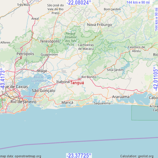
Tanguá GPS coordinates[2]
22° 43' 49.008" South, 42° 42' 51.012" West
| Map corner | latitude | longitude |
|---|---|---|
| Upper-left | -22.08024°, | -43.4173° |
| Center: | -22.73028°, | -42.71417° |
| Lower-right: | -23.37725°, | -42.01105° |
| Map W x H: | 144.2×144.2 km | = 89.6×89.6mi |
| max Lat: | 2.81972° ⇑75.6% North |
| Tanguá: | -22.73028° |
| min Lat: | ⇓24.4% South -33.69111° |
| min Long | Tanguá | max Long |
| -72.89583° | -42.71417° | -32.41083° |
| W 62.2%⇐ | ⇒37.8% E |
Elevation
Elevation of Tanguá is 30 m = 98 ft, and this is 350.9 m = 1151 ft below average elevation for this country.
| Max E: |
1603 m = 5259 ft | 85.2% |
| Avg. | 380.9 m = 1250 ft | |
| Tanguá | 30 m = 98 ft | |
Min E: |
0 m = 0 ft | 14.8% |
See also: Brazil elevation on elevation.city.
Geographical zone
Tanguá is located in South Torrid zone (between Equator and Tropic of Capricorn). Distance of this Southern Tropic circle is 78.5 km =48.8 mi to South.| Distance of | km | miles | from Tanguá |
|---|---|---|---|
| Equator | 2527.4 | 1570.5 | to North |
| Tropic Capricorn | 78.5 | 48.8 | to South |
| Antarctic Circle | 4873.8 | 3028.4 | to South |
| South Pole | 7479.7 | 4647.7 | to South |


Nearby cities:
15 places around Tanguá: (largest is in red/bold)
• Araruama
41.2 km =25.6 mi,  112°
112°
• Cachoeiras de Macacu
30.4 km =18.9 mi,  11°
11°
• Guapimirim
34.9 km =21.7 mi,  307°
307°
• Iguaba Grande
51.2 km =31.8 mi,  103°
103°
• Itaboraí
15 km =9.3 mi,  263°
263°
• Maricá
23.6 km =14.7 mi,  206°
206°
• Niterói
43.4 km =27 mi,  246°
246°
• Nova Friburgo
53.3 km =33.1 mi,  20°
20°
• Rio Bonito
11 km =6.8 mi,  77°
77°
• Rio de Janeiro
51.8 km =32.2 mi, 247°
• Saquarema
29.7 km =18.5 mi,  135°
135°
• Silva Jardim
34.2 km =21.3 mi, 75°
• São Gonçalo
36.4 km =22.6 mi, 252°
• São Pedro
42.8 km =26.6 mi,  322°
322°
• Teresópolis
44.2 km =27.5 mi, 322°
Sources, notices
• [Note1] Compared only with cities in Brazil existing in our database
• [Src1] Map data: © OpenStreetMap contributors (CC-BY-SA)
• [Src2] Other city data from geonames.org with taken over terms of usage.
• [Src3] Geographical zone / Annual Mean Temperature by Robert A. Rohde @ Wikipedia
