Iguaba Grande geodata
Iguaba Grande (Rio de Janeiro) is a populated place; located in Brazil in America/Sao_Paulo (GMT-3) time zone. With population of 11,104 people, there are 1559 cities with bigger population in this country. Compared to other cities in Brazil, 77.1% of cities are located further ↑North; 64.8% of cities are located further ←West and 90.4% of cities have higher elevation than Iguaba Grande. Note1


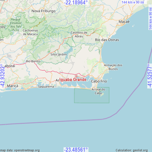
Iguaba Grande GPS coordinates[2]
22° 50' 21.012" South, 42° 13' 44.004" West
| Map corner | latitude | longitude |
|---|---|---|
| Upper-left | -22.18964°, | -42.93202° |
| Center: | -22.83917°, | -42.22889° |
| Lower-right: | -23.48561°, | -41.52577° |
| Map W x H: | 144.1×144.1 km | = 89.5×89.5mi |
| max Lat: | 2.81972° ⇑77.1% North |
| Iguaba Grande: | -22.83917° |
| min Lat: | ⇓22.9% South -33.69111° |
| min Long | Iguaba Grande | max Long |
| -72.89583° | -42.22889° | -32.41083° |
| W 64.8%⇐ | ⇒35.2% E |
Elevation
Elevation of Iguaba Grande is 17 m = 56 ft, and this is 363.9 m = 1194 ft below average elevation for this country.
| Max E: |
1603 m = 5259 ft | 90.4% |
| Avg. | 380.9 m = 1250 ft | |
| Iguaba Grande | 17 m = 56 ft | |
Min E: |
0 m = 0 ft | 9.6% |
See also: Brazil elevation on elevation.city.
Geographical zone
Iguaba Grande is located in South Torrid zone (between Equator and Tropic of Capricorn). Distance of this Southern Tropic circle is 66.4 km =41.3 mi to South.| Distance of | km | miles | from Iguaba Grande |
|---|---|---|---|
| Equator | 2539.5 | 1578 | to North |
| Tropic Capricorn | 66.4 | 41.3 | to South |
| Antarctic Circle | 4861.7 | 3020.9 | to South |
| South Pole | 7467.6 | 4640.2 | to South |


Nearby cities:
15 places around Iguaba Grande: (largest is in red/bold)
• Araruama
12.3 km =7.6 mi,  252°
252°
• Armação de Búzios
37 km =23 mi,  73°
73°
• Arraial do Cabo
25 km =15.5 mi,  124°
124°
• Cabo Frio
21.4 km =13.3 mi,  104°
104°
• Cachoeiras de Macacu
60.4 km =37.5 mi,  313°
313°
• Casimiro de Abreu
40 km =24.9 mi,  3°
3°
• Itaboraí
65.5 km =40.7 mi,  279°
279°
• Macaé
68.1 km =42.3 mi,  42°
42°
• Maricá
61.1 km =38 mi,  261°
261°
• Rio Bonito
41.7 km =25.9 mi,  290°
290°
• Rio das Ostras
45.3 km =28.1 mi, 39°
• Saquarema
30.2 km =18.8 mi, 252°
• Silva Jardim
26.8 km =16.7 mi,  321°
321°
• São Pedro da Aldeia
12.9 km =8 mi,  90°
90°
• Tanguá
51.2 km =31.8 mi, 283°
Sources, notices
• [Note1] Compared only with cities in Brazil existing in our database
• [Src1] Map data: © OpenStreetMap contributors (CC-BY-SA)
• [Src2] Other city data from geonames.org with taken over terms of usage.
• [Src3] Geographical zone / Annual Mean Temperature by Robert A. Rohde @ Wikipedia
