Araruama geodata
Araruama (Rio de Janeiro) is a populated place; located in Brazil in America/Sao_Paulo (GMT-3) time zone. With population of 109,637 people, there are 206 cities with bigger population in this country. Compared to other cities in Brazil, 77.5% of cities are located further ↑North; 64.3% of cities are located further ←West and 88.9% of cities have higher elevation than Araruama. Note1


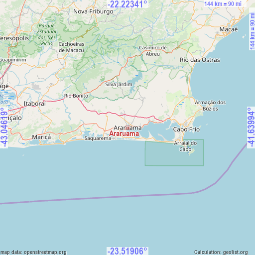
Araruama GPS coordinates[2]
22° 52' 22.008" South, 42° 20' 35.016" West
| Map corner | latitude | longitude |
|---|---|---|
| Upper-left | -22.22341°, | -43.04619° |
| Center: | -22.87278°, | -42.34306° |
| Lower-right: | -23.51906°, | -41.63994° |
| Map W x H: | 144.1×144.1 km | = 89.5×89.5mi |
| max Lat: | 2.81972° ⇑77.5% North |
| Araruama: | -22.87278° |
| min Lat: | ⇓22.5% South -33.69111° |
| min Long | Araruama | max Long |
| -72.89583° | -42.34306° | -32.41083° |
| W 64.3%⇐ | ⇒35.7% E |
Elevation
Elevation of Araruama is 20 m = 66 ft, and this is 360.9 m = 1184 ft below average elevation for this country.
| Max E: |
1603 m = 5259 ft | 88.9% |
| Avg. | 380.9 m = 1250 ft | |
| Araruama | 20 m = 66 ft | |
Min E: |
0 m = 0 ft | 11.1% |
See also: Araruama elevation on elevation.city.
Geographical zone
Araruama is located in South Torrid zone (between Equator and Tropic of Capricorn). Distance of this Southern Tropic circle is 62.7 km =39 mi to South.| Distance of | km | miles | from Araruama |
|---|---|---|---|
| Equator | 2543.2 | 1580.3 | to North |
| Tropic Capricorn | 62.7 | 39 | to South |
| Antarctic Circle | 4858 | 3018.6 | to South |
| South Pole | 7463.8 | 4637.8 | to South |


Nearby cities:
15 places around Araruama: (largest is in red/bold)
• Armação de Búzios
49.3 km =30.6 mi,  73°
73°
• Arraial do Cabo
33.9 km =21.1 mi,  107°
107°
• Cabo Frio
32.5 km =20.2 mi,  92°
92°
• Cachoeiras de Macacu
55.6 km =34.5 mi,  325°
325°
• Casimiro de Abreu
45.9 km =28.5 mi,  18°
18°
• Iguaba Grande
12.3 km =7.6 mi, 72°
• Itaboraí
54.8 km =34.1 mi,  285°
285°
• Maricá
49 km =30.4 mi,  263°
263°
• Nova Friburgo
68.5 km =42.6 mi,  343°
343°
• Rio Bonito
32.9 km =20.4 mi,  303°
303°
• Rio das Ostras
56.1 km =34.9 mi,  46°
46°
• Saquarema
17.9 km =11.1 mi,  252°
252°
• Silva Jardim
25.2 km =15.7 mi,  348°
348°
• São Pedro da Aldeia
24.9 km =15.5 mi,  81°
81°
• Tanguá
41.2 km =25.6 mi, 292°
Sources, notices
• [Note1] Compared only with cities in Brazil existing in our database
• [Src1] Map data: © OpenStreetMap contributors (CC-BY-SA)
• [Src2] Other city data from geonames.org with taken over terms of usage.
• [Src3] Geographical zone / Annual Mean Temperature by Robert A. Rohde @ Wikipedia
