Santa Rosa de Viterbo geodata
Santa Rosa de Viterbo (São Paulo) is a populated place; located in Brazil in America/Sao_Paulo (GMT-3) time zone. With population of 21,473 people, there are 888 cities with bigger population in this country. Compared to other cities in Brazil, 66.4% of cities are located further ↑North; 60.5% of cities are located further →East and 78.9% of cities have lower elevation than Santa Rosa de Viterbo. Note1


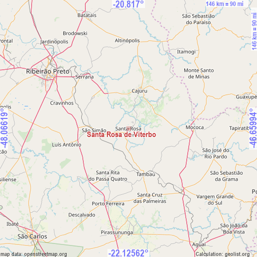
Santa Rosa de Viterbo GPS coordinates[2]
21° 28' 22.008" South, 47° 21' 47.016" West
| Map corner | latitude | longitude |
|---|---|---|
| Upper-left | -20.817°, | -48.06619° |
| Center: | -21.47278°, | -47.36306° |
| Lower-right: | -22.12562°, | -46.65994° |
| Map W x H: | 145.5×145.5 km | = 90.4×90.4mi |
| max Lat: | 2.81972° ⇑66.4% North |
| Santa Rosa de Viterbo: | -21.47278° |
| min Lat: | ⇓33.6% South -33.69111° |
| min Long | Santa Rosa de V | max Long |
| -72.89583° | -47.36306° | -32.41083° |
| W 39.5%⇐ | ⇒60.5% E |
Elevation
Elevation of Santa Rosa de Viterbo is 677 m = 2221 ft, and this is 296.1 m = 971 ft above average elevation for this country.
| Max E: |
1603 m = 5259 ft | 21.1% |
| Santa Rosa de Viterbo | 677 m 2221 ft | |
| Avg. | 380.9 m = 1250 ft | |
Min E: |
0 m = 0 ft | 78.9% |
See also: Brazil elevation on elevation.city.
Geographical zone
Santa Rosa de Viterbo is located in South Torrid zone (between Equator and Tropic of Capricorn). Distance of this Southern Tropic circle is 218.4 km =135.7 mi to South.| Distance of | km | miles | from Santa Rosa de Viterbo |
|---|---|---|---|
| Equator | 2387.5 | 1483.5 | to North |
| Tropic Capricorn | 218.4 | 135.7 | to South |
| Antarctic Circle | 5013.6 | 3115.3 | to South |
| South Pole | 7619.5 | 4734.5 | to South |


Nearby cities:
15 places around Santa Rosa de Viterbo: (largest is in red/bold)
• Altinópolis
49.7 km =30.9 mi,  358°
358°
• Cajuru
22.8 km =14.2 mi,  15°
15°
• Casa Branca
44 km =27.3 mi,  139°
139°
• Cravinhos
40.7 km =25.3 mi,  291°
291°
• Descalvado
54.8 km =34.1 mi,  208°
208°
• Mococa
37.1 km =23.1 mi,  89°
89°
• Monte Santo de Minas
50.6 km =31.4 mi,  51°
51°
• Porto Ferreira
44 km =27.3 mi,  195°
195°
• Ribeirão Preto
56.8 km =35.3 mi,  305°
305°
• Santa Cruz das Palmeiras
41.1 km =25.5 mi,  163°
163°
• Santa Rita do Passa Quatro
29 km =18 mi, 204°
• Serrana
37.7 km =23.4 mi,  320°
320°
• São José do Rio Pardo
50.9 km =31.6 mi,  105°
105°
• São Simão
19.4 km =12.1 mi,  267°
267°
• Tambaú
27.4 km =17 mi, 160°
Sources, notices
• [Note1] Compared only with cities in Brazil existing in our database
• [Src1] Map data: © OpenStreetMap contributors (CC-BY-SA)
• [Src2] Other city data from geonames.org with taken over terms of usage.
• [Src3] Geographical zone / Annual Mean Temperature by Robert A. Rohde @ Wikipedia
