Ribeirão Preto geodata
Ribeirão Preto (São Paulo) is a seat of a second-order administrative division; located in Brazil in America/Sao_Paulo (GMT-3) time zone. With population of 619,746 people, there are 28 cities with bigger population in this country. Compared to other cities in Brazil, 64.2% of cities are located further ↑North; 63.5% of cities are located further →East and 67.6% of cities have lower elevation than Ribeirão Preto. Note1


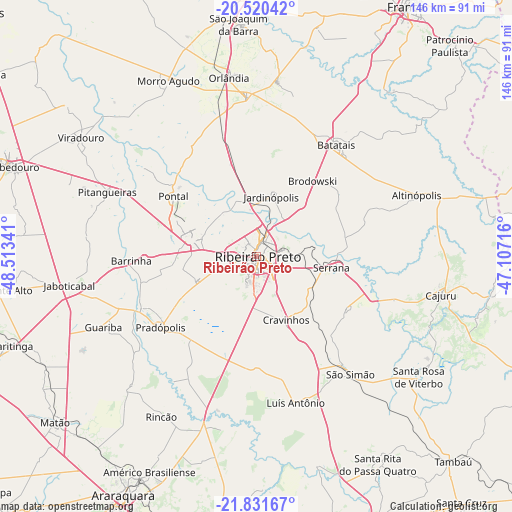
Ribeirão Preto GPS coordinates[2]
21° 10' 39" South, 47° 48' 37.008" West
| Map corner | latitude | longitude |
|---|---|---|
| Upper-left | -20.52042°, | -48.51341° |
| Center: | -21.1775°, | -47.81028° |
| Lower-right: | -21.83167°, | -47.10716° |
| Map W x H: | 145.8×145.8 km | = 90.6×90.6mi |
| max Lat: | 2.81972° ⇑64.2% North |
| Ribeirão Preto: | -21.1775° |
| min Lat: | ⇓35.8% South -33.69111° |
| min Long | Ribeirão Preto | max Long |
| -72.89583° | -47.81028° | -32.41083° |
| W 36.5%⇐ | ⇒63.5% E |
Elevation
Elevation of Ribeirão Preto is 554 m = 1818 ft, and this is 173.1 m = 568 ft above average elevation for this country.
| Max E: |
1603 m = 5259 ft | 32.4% |
| Ribeirão Preto | 554 m 1818 ft | |
| Avg. | 380.9 m = 1250 ft | |
Min E: |
0 m = 0 ft | 67.6% |
See also: Ribeirão Preto elevation on elevation.city.
Geographical zone
Ribeirão Preto is located in South Torrid zone (between Equator and Tropic of Capricorn). Distance of this Southern Tropic circle is 251.2 km =156.1 mi to South.| Distance of | km | miles | from Ribeirão Preto |
|---|---|---|---|
| Equator | 2354.7 | 1463.1 | to North |
| Tropic Capricorn | 251.2 | 156.1 | to South |
| Antarctic Circle | 5046.5 | 3135.7 | to South |
| South Pole | 7652.3 | 4754.9 | to South |


Nearby cities:
15 places around Ribeirão Preto: (largest is in red/bold)
• Altinópolis
48.3 km =30 mi,  69°
69°
• Barrinha
36.7 km =22.8 mi,  267°
267°
• Batatais
39.5 km =24.5 mi,  36°
36°
• Brodósqui
26 km =16.2 mi, 37°
• Cravinhos
19.9 km =12.4 mi,  155°
155°
• Guariba
47.8 km =29.7 mi,  244°
244°
• Jardinópolis
18.4 km =11.4 mi,  15°
15°
• Nuporanga
50 km =31.1 mi,  6°
6°
• Orlândia
51.5 km =32 mi,  351°
351°
• Pitangueiras
46.6 km =29 mi,  293°
293°
• Pontal
29.2 km =18.1 mi,  306°
306°
• Pradópolis
33.3 km =20.7 mi,  232°
232°
• Serrana
22.6 km =14 mi,  99°
99°
• Sertãozinho
19.2 km =11.9 mi,  283°
283°
• São Simão
43 km =26.7 mi,  141°
141°
Sources, notices
• [Note1] Compared only with cities in Brazil existing in our database
• [Src1] Map data: © OpenStreetMap contributors (CC-BY-SA)
• [Src2] Other city data from geonames.org with taken over terms of usage.
• [Src3] Geographical zone / Annual Mean Temperature by Robert A. Rohde @ Wikipedia
