Serrana geodata
Serrana (São Paulo) is a populated place; located in Brazil in America/Sao_Paulo (GMT-3) time zone. With population of 39,826 people, there are 530 cities with bigger population in this country. Compared to other cities in Brazil, 64.7% of cities are located further ↑North; 62.4% of cities are located further →East and 68.2% of cities have lower elevation than Serrana. Note1


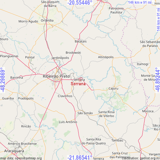
Serrana GPS coordinates[2]
21° 12' 41.004" South, 47° 35' 44.016" West
| Map corner | latitude | longitude |
|---|---|---|
| Upper-left | -20.55446°, | -48.29869° |
| Center: | -21.21139°, | -47.59556° |
| Lower-right: | -21.86541°, | -46.89244° |
| Map W x H: | 145.8×145.8 km | = 90.6×90.6mi |
| max Lat: | 2.81972° ⇑64.7% North |
| Serrana: | -21.21139° |
| min Lat: | ⇓35.3% South -33.69111° |
| min Long | Serrana | max Long |
| -72.89583° | -47.59556° | -32.41083° |
| W 37.6%⇐ | ⇒62.4% E |
Elevation
Elevation of Serrana is 560 m = 1837 ft, and this is 179.1 m = 588 ft above average elevation for this country.
| Max E: |
1603 m = 5259 ft | 31.8% |
| Serrana | 560 m 1837 ft | |
| Avg. | 380.9 m = 1250 ft | |
Min E: |
0 m = 0 ft | 68.2% |
See also: Brazil elevation on elevation.city.
Geographical zone
Serrana is located in South Torrid zone (between Equator and Tropic of Capricorn). Distance of this Southern Tropic circle is 247.4 km =153.7 mi to South.| Distance of | km | miles | from Serrana |
|---|---|---|---|
| Equator | 2358.5 | 1465.5 | to North |
| Tropic Capricorn | 247.4 | 153.7 | to South |
| Antarctic Circle | 5042.7 | 3133.4 | to South |
| South Pole | 7648.6 | 4752.6 | to South |


Nearby cities:
15 places around Serrana: (largest is in red/bold)
• Altinópolis
30.9 km =19.2 mi,  48°
48°
• Barrinha
58.9 km =36.6 mi,  271°
271°
• Batatais
35.6 km =22.1 mi,  1°
1°
• Brodósqui
25.3 km =15.7 mi,  345°
345°
• Cajuru
31 km =19.3 mi,  103°
103°
• Cravinhos
19.9 km =12.4 mi,  224°
224°
• Jardinópolis
27.7 km =17.2 mi,  320°
320°
• Nuporanga
55.8 km =34.7 mi,  343°
343°
• Pontal
50.4 km =31.3 mi,  294°
294°
• Pradópolis
51.4 km =31.9 mi,  251°
251°
• Ribeirão Preto
22.6 km =14 mi,  279°
279°
• Santa Rita do Passa Quatro
56.8 km =35.3 mi,  167°
167°
• Santa Rosa de Viterbo
37.7 km =23.4 mi,  140°
140°
• Sertãozinho
41.7 km =25.9 mi, 281°
• São Simão
30.1 km =18.7 mi, 171°
Sources, notices
• [Note1] Compared only with cities in Brazil existing in our database
• [Src1] Map data: © OpenStreetMap contributors (CC-BY-SA)
• [Src2] Other city data from geonames.org with taken over terms of usage.
• [Src3] Geographical zone / Annual Mean Temperature by Robert A. Rohde @ Wikipedia
