Santa Isabel geodata
Santa Isabel (São Paulo) is a populated place; located in Brazil in America/Sao_Paulo (GMT-3) time zone. With population of 33,709 people, there are 612 cities with bigger population in this country. Compared to other cities in Brazil, 81.2% of cities are located further ↑North; 53.4% of cities are located further →East and 77.4% of cities have lower elevation than Santa Isabel. Note1


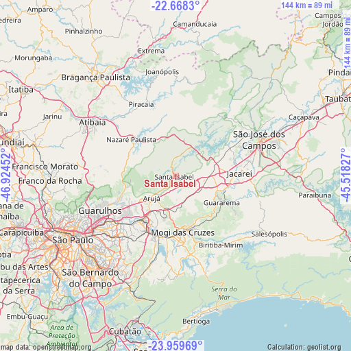
Santa Isabel GPS coordinates[2]
23° 18' 56.016" South, 46° 13' 17.004" West
| Map corner | latitude | longitude |
|---|---|---|
| Upper-left | -22.6683°, | -46.92452° |
| Center: | -23.31556°, | -46.22139° |
| Lower-right: | -23.95969°, | -45.51827° |
| Map W x H: | 143.6×143.6 km | = 89.2×89.2mi |
| max Lat: | 2.81972° ⇑81.2% North |
| Santa Isabel: | -23.31556° |
| min Lat: | ⇓18.8% South -33.69111° |
| min Long | Santa Isabel | max Long |
| -72.89583° | -46.22139° | -32.41083° |
| W 46.6%⇐ | ⇒53.4% E |
Elevation
Elevation of Santa Isabel is 658 m = 2159 ft, and this is 277.1 m = 909 ft above average elevation for this country.
| Max E: |
1603 m = 5259 ft | 22.6% |
| Santa Isabel | 658 m 2159 ft | |
| Avg. | 380.9 m = 1250 ft | |
Min E: |
0 m = 0 ft | 77.4% |
See also: Brazil elevation on elevation.city.
Geographical zone
Santa Isabel is located in South Torrid zone (between Equator and Tropic of Capricorn). Distance of this Southern Tropic circle is 13.5 km =8.4 mi to South.| Distance of | km | miles | from Santa Isabel |
|---|---|---|---|
| Equator | 2592.4 | 1610.8 | to North |
| Tropic Capricorn | 13.5 | 8.4 | to South |
| Antarctic Circle | 4808.7 | 2988 | to South |
| South Pole | 7414.6 | 4607.2 | to South |


Nearby cities:
15 places around Santa Isabel: (largest is in red/bold)
• Arujá
13.5 km =8.4 mi,  228°
228°
• Biritiba Mirim
34.1 km =21.2 mi,  146°
146°
• Bom Jesus dos Perdões
32 km =19.9 mi,  308°
308°
• Ferraz de Vasconcelos
29.2 km =18.1 mi,  210°
210°
• Guararema
22 km =13.7 mi,  120°
120°
• Guarulhos
35.8 km =22.2 mi,  242°
242°
• Itaquaquecetuba
23 km =14.3 mi, 214°
• Jacareí
26.1 km =16.2 mi,  87°
87°
• Mairiporã
37.3 km =23.2 mi,  269°
269°
• Mogi das Cruzes
23.3 km =14.5 mi,  171°
171°
• Piracaia
32.3 km =20.1 mi,  334°
334°
• Poá
26.8 km =16.7 mi, 208°
• Santa Branca
35.6 km =22.1 mi,  104°
104°
• Suzano
26.8 km =16.7 mi,  199°
199°
• São José dos Campos
37.4 km =23.2 mi,  66°
66°
Sources, notices
• [Note1] Compared only with cities in Brazil existing in our database
• [Src1] Map data: © OpenStreetMap contributors (CC-BY-SA)
• [Src2] Other city data from geonames.org with taken over terms of usage.
• [Src3] Geographical zone / Annual Mean Temperature by Robert A. Rohde @ Wikipedia
