Suzano geodata
Suzano (São Paulo) is a populated place; located in Brazil in America/Sao_Paulo (GMT-3) time zone. With population of 283,314 people, there are 79 cities with bigger population in this country. Compared to other cities in Brazil, 83.1% of cities are located further ↑North; 53.6% of cities are located further →East and 83.9% of cities have lower elevation than Suzano. Note1


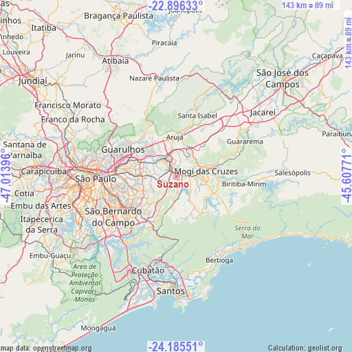
Suzano GPS coordinates[2]
23° 32' 33" South, 46° 18' 38.988" West
| Map corner | latitude | longitude |
|---|---|---|
| Upper-left | -22.89633°, | -47.01396° |
| Center: | -23.5425°, | -46.31083° |
| Lower-right: | -24.18551°, | -45.60771° |
| Map W x H: | 143.3×143.3 km | = 89×89mi |
| max Lat: | 2.81972° ⇑83.1% North |
| Suzano: | -23.5425° |
| min Lat: | ⇓16.9% South -33.69111° |
| min Long | Suzano | max Long |
| -72.89583° | -46.31083° | -32.41083° |
| W 46.4%⇐ | ⇒53.6% E |
Elevation
Elevation of Suzano is 747 m = 2451 ft, and this is 366.1 m = 1201 ft above average elevation for this country.
| Max E: |
1603 m = 5259 ft | 16.1% |
| Suzano | 747 m 2451 ft | |
| Avg. | 380.9 m = 1250 ft | |
Min E: |
0 m = 0 ft | 83.9% |
See also: Suzano elevation on elevation.city.
Geographical zone
Suzano is located in South temperate zone (between Tropic of Capricorn and the Antarctic Circle). Distance of this Southern Tropic circle is 11.8 km =7.3 mi to North.| Distance of | km | miles | from Suzano |
|---|---|---|---|
| Equator | 2617.7 | 1626.6 | to North |
| Tropic Capricorn | 11.8 | 7.3 | to North |
| Antarctic Circle | 4783.5 | 2972.3 | to South |
| South Pole | 7389.4 | 4591.6 | to South |


Nearby cities:
15 places around Suzano: (largest is in red/bold)
• Arujá
16.3 km =10.1 mi,  356°
356°
• Biritiba Mirim
27.9 km =17.3 mi,  96°
96°
• Ferraz de Vasconcelos
5.9 km =3.7 mi,  271°
271°
• Guararema
31.5 km =19.6 mi,  63°
63°
• Guarulhos
24.4 km =15.2 mi,  291°
291°
• Itaquaquecetuba
7.3 km =4.5 mi,  328°
328°
• Mauá
20.7 km =12.9 mi,  227°
227°
• Mogi das Cruzes
12.7 km =7.9 mi,  80°
80°
• Poá
3.8 km =2.4 mi, 294°
• Ribeirão Pires
21.4 km =13.3 mi,  209°
209°
• Rio Grande da Serra
24.1 km =15 mi,  201°
201°
• Santa Isabel
26.8 km =16.7 mi,  19°
19°
• Santo André
26.8 km =16.7 mi,  239°
239°
• São Bernardo do Campo
30.9 km =19.2 mi, 236°
• São Caetano do Sul
26.1 km =16.2 mi,  249°
249°
Sources, notices
• [Note1] Compared only with cities in Brazil existing in our database
• [Src1] Map data: © OpenStreetMap contributors (CC-BY-SA)
• [Src2] Other city data from geonames.org with taken over terms of usage.
• [Src3] Geographical zone / Annual Mean Temperature by Robert A. Rohde @ Wikipedia
