Bom Jesus dos Perdões geodata
Bom Jesus dos Perdões (São Paulo) is a populated place; located in Brazil in America/Sao_Paulo (GMT-3) time zone. With population of 12,422 people, there are 1431 cities with bigger population in this country. Compared to other cities in Brazil, 79.9% of cities are located further ↑North; 54.8% of cities are located further →East and 88.2% of cities have lower elevation than Bom Jesus dos Perdões. Note1


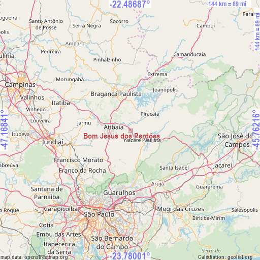
Bom Jesus dos Perdões GPS coordinates[2]
23° 8' 6" South, 46° 27' 55.008" West
| Map corner | latitude | longitude |
|---|---|---|
| Upper-left | -22.48687°, | -47.16841° |
| Center: | -23.135°, | -46.46528° |
| Lower-right: | -23.78001°, | -45.76216° |
| Map W x H: | 143.8×143.8 km | = 89.4×89.4mi |
| max Lat: | 2.81972° ⇑79.9% North |
| Bom Jesus dos Perdões: | -23.135° |
| min Lat: | ⇓20.1% South -33.69111° |
| min Long | Bom Jesus dos P | max Long |
| -72.89583° | -46.46528° | -32.41083° |
| W 45.2%⇐ | ⇒54.8% E |
Elevation
Elevation of Bom Jesus dos Perdões is 788 m = 2585 ft, and this is 407.1 m = 1336 ft above average elevation for this country.
| Max E: |
1603 m = 5259 ft | 11.8% |
| Bom Jesus dos Perdões | 788 m 2585 ft | |
| Avg. | 380.9 m = 1250 ft | |
Min E: |
0 m = 0 ft | 88.2% |
See also: Brazil elevation on elevation.city.
Geographical zone
Bom Jesus dos Perdões is located in South Torrid zone (between Equator and Tropic of Capricorn). Distance of this Southern Tropic circle is 33.5 km =20.8 mi to South.| Distance of | km | miles | from Bom Jesus dos Perdões |
|---|---|---|---|
| Equator | 2572.4 | 1598.4 | to North |
| Tropic Capricorn | 33.5 | 20.8 | to South |
| Antarctic Circle | 4828.8 | 3000.5 | to South |
| South Pole | 7434.7 | 4619.7 | to South |


Nearby cities:
15 places around Bom Jesus dos Perdões: (largest is in red/bold)
• Arujá
32.6 km =20.3 mi,  153°
153°
• Atibaia
8.9 km =5.5 mi,  283°
283°
• Bragança Paulista
21.8 km =13.5 mi,  338°
338°
• Caieiras
37.9 km =23.5 mi,  227°
227°
• Campo Limpo Paulista
33.6 km =20.9 mi,  256°
256°
• Extrema
34.6 km =21.5 mi,  25°
25°
• Francisco Morato
32.9 km =20.4 mi,  240°
240°
• Franco da Rocha
33.8 km =21 mi, 232°
• Guarulhos
37.1 km =23.1 mi,  190°
190°
• Jarinu
27.2 km =16.9 mi, 277°
• Joanópolis
29.9 km =18.6 mi,  40°
40°
• Mairiporã
23.9 km =14.9 mi,  211°
211°
• Piracaia
14.2 km =8.8 mi,  50°
50°
• Santa Isabel
32 km =19.9 mi,  128°
128°
• Várzea Paulista
38.1 km =23.7 mi, 257°
Sources, notices
• [Note1] Compared only with cities in Brazil existing in our database
• [Src1] Map data: © OpenStreetMap contributors (CC-BY-SA)
• [Src2] Other city data from geonames.org with taken over terms of usage.
• [Src3] Geographical zone / Annual Mean Temperature by Robert A. Rohde @ Wikipedia
