Itaúna geodata
Itaúna (Minas Gerais) is a populated place; located in Brazil in America/Sao_Paulo (GMT-3) time zone. With population of 77,400 people, there are 295 cities with bigger population in this country. Compared to other cities in Brazil, 57.6% of cities are located further ↑North; 53.1% of cities are located further ←West and 92.3% of cities have lower elevation than Itaúna. Note1


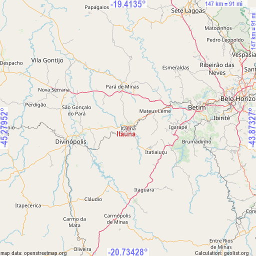
Itaúna GPS coordinates[2]
20° 4' 31.008" South, 44° 34' 35.004" West
| Map corner | latitude | longitude |
|---|---|---|
| Upper-left | -19.4135°, | -45.27952° |
| Center: | -20.07528°, | -44.57639° |
| Lower-right: | -20.73428°, | -43.87327° |
| Map W x H: | 146.9×146.9 km | = 91.3×91.3mi |
| max Lat: | 2.81972° ⇑57.6% North |
| Itaúna: | -20.07528° |
| min Lat: | ⇓42.4% South -33.69111° |
| min Long | Itaúna | max Long |
| -72.89583° | -44.57639° | -32.41083° |
| W 53.1%⇐ | ⇒46.9% E |
Elevation
Elevation of Itaúna is 848 m = 2782 ft, and this is 467.1 m = 1532 ft above average elevation for this country.
| Max E: |
1603 m = 5259 ft | 7.7% |
| Itaúna | 848 m 2782 ft | |
| Avg. | 380.9 m = 1250 ft | |
Min E: |
0 m = 0 ft | 92.3% |
See also: Itaúna elevation on elevation.city.
Geographical zone
Itaúna is located in South Torrid zone (between Equator and Tropic of Capricorn). Distance of this Southern Tropic circle is 373.8 km =232.3 mi to South.| Distance of | km | miles | from Itaúna |
|---|---|---|---|
| Equator | 2232.2 | 1387 | to North |
| Tropic Capricorn | 373.8 | 232.3 | to South |
| Antarctic Circle | 5169 | 3211.9 | to South |
| South Pole | 7774.9 | 4831.1 | to South |


Nearby cities:
15 places around Itaúna: (largest is in red/bold)
• Betim
41.3 km =25.7 mi,  73°
73°
• Brumadinho
40 km =24.9 mi,  100°
100°
• Carmo do Cajuru
23.7 km =14.7 mi,  239°
239°
• Cláudio
45.4 km =28.2 mi,  205°
205°
• Contagem
56.9 km =35.4 mi, 73°
• Divinópolis
33.7 km =20.9 mi,  256°
256°
• Esmeraldas
44.3 km =27.5 mi,  38°
38°
• Ibirité
54.4 km =33.8 mi,  83°
83°
• Igarapé
28.7 km =17.8 mi,  88°
88°
• Juatuba
28 km =17.4 mi,  60°
60°
• Mateus Leme
18.4 km =11.4 mi, 57°
• Pará de Minas
24.1 km =15 mi,  352°
352°
• Pitangui
54.6 km =33.9 mi,  323°
323°
• Sarzedo
45.3 km =28.1 mi, 84°
• São Joaquim de Bicas
31.7 km =19.7 mi, 84°
Sources, notices
• [Note1] Compared only with cities in Brazil existing in our database
• [Src1] Map data: © OpenStreetMap contributors (CC-BY-SA)
• [Src2] Other city data from geonames.org with taken over terms of usage.
• [Src3] Geographical zone / Annual Mean Temperature by Robert A. Rohde @ Wikipedia
