Igarapé geodata
Igarapé (Minas Gerais) is a populated place; located in Brazil in America/Sao_Paulo (GMT-3) time zone. With population of 21,427 people, there are 890 cities with bigger population in this country. Compared to other cities in Brazil, 57.5% of cities are located further ↑North; 54.3% of cities are located further ←West and 89.9% of cities have lower elevation than Igarapé. Note1


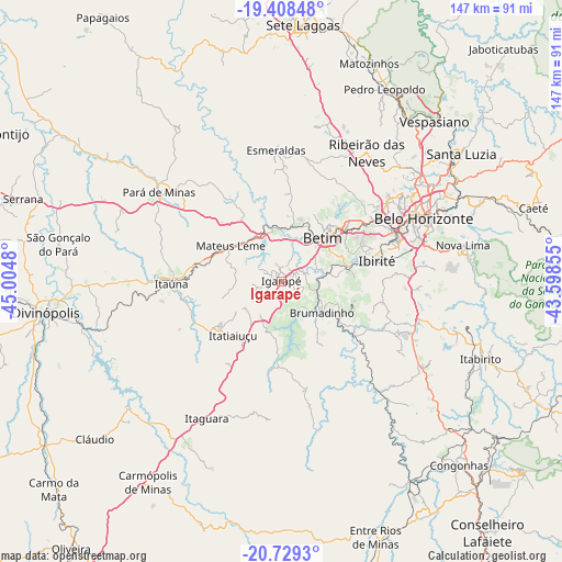
Igarapé GPS coordinates[2]
20° 4' 13.008" South, 44° 18' 6.012" West
| Map corner | latitude | longitude |
|---|---|---|
| Upper-left | -19.40848°, | -45.0048° |
| Center: | -20.07028°, | -44.30167° |
| Lower-right: | -20.7293°, | -43.59855° |
| Map W x H: | 146.9×146.9 km | = 91.3×91.3mi |
| max Lat: | 2.81972° ⇑57.5% North |
| Igarapé: | -20.07028° |
| min Lat: | ⇓42.5% South -33.69111° |
| min Long | Igarapé | max Long |
| -72.89583° | -44.30167° | -32.41083° |
| W 54.3%⇐ | ⇒45.7% E |
Elevation
Elevation of Igarapé is 812 m = 2664 ft, and this is 431.1 m = 1414 ft above average elevation for this country.
| Max E: |
1603 m = 5259 ft | 10.1% |
| Igarapé | 812 m 2664 ft | |
| Avg. | 380.9 m = 1250 ft | |
Min E: |
0 m = 0 ft | 89.9% |
See also: Brazil elevation on elevation.city.
Geographical zone
Igarapé is located in South Torrid zone (between Equator and Tropic of Capricorn). Distance of this Southern Tropic circle is 374.3 km =232.6 mi to South.| Distance of | km | miles | from Igarapé |
|---|---|---|---|
| Equator | 2231.6 | 1386.7 | to North |
| Tropic Capricorn | 374.3 | 232.6 | to South |
| Antarctic Circle | 5169.6 | 3212.2 | to South |
| South Pole | 7775.5 | 4831.5 | to South |


Nearby cities:
15 places around Igarapé: (largest is in red/bold)
• Belo Horizonte
41.5 km =25.8 mi,  66°
66°
• Betim
15.7 km =9.8 mi,  43°
43°
• Brumadinho
13.4 km =8.3 mi,  127°
127°
• Carmo do Cajuru
50.6 km =31.4 mi,  255°
255°
• Contagem
30.2 km =18.8 mi,  59°
59°
• Esmeraldas
34.2 km =21.3 mi,  357°
357°
• Ibirité
25.9 km =16.1 mi,  78°
78°
• Itaúna
28.7 km =17.8 mi,  268°
268°
• Juatuba
13.8 km =8.6 mi,  341°
341°
• Mateus Leme
16.1 km =10 mi,  305°
305°
• Nova Lima
48.5 km =30.1 mi, 78°
• Pará de Minas
39.7 km =24.7 mi, 306°
• Ribeirão das Neves
40.5 km =25.2 mi,  33°
33°
• Sarzedo
16.8 km =10.4 mi, 76°
• São Joaquim de Bicas
3.7 km =2.3 mi,  51°
51°
Sources, notices
• [Note1] Compared only with cities in Brazil existing in our database
• [Src1] Map data: © OpenStreetMap contributors (CC-BY-SA)
• [Src2] Other city data from geonames.org with taken over terms of usage.
• [Src3] Geographical zone / Annual Mean Temperature by Robert A. Rohde @ Wikipedia
