Irecê geodata
Irecê (Bahia) is a populated place; located in Brazil in America/Bahia (GMT-3) time zone. With population of 63,626 people, there are 351 cities with bigger population in this country. Compared to other cities in Brazil, 64.1% of cities are located further ↓South; 66.6% of cities are located further ←West and 82.9% of cities have lower elevation than Irecê. Note1


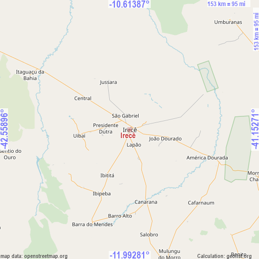
Irecê GPS coordinates[2]
11° 18' 15.012" South, 41° 51' 20.988" West
| Map corner | latitude | longitude |
|---|---|---|
| Upper-left | -10.61387°, | -42.55896° |
| Center: | -11.30417°, | -41.85583° |
| Lower-right: | -11.99281°, | -41.15271° |
| Map W x H: | 153.3×153.3 km | = 95.3×95.3mi |
| max Lat: | 2.81972° ⇑35.9% North |
| Irecê: | -11.30417° |
| min Lat: | ⇓64.1% South -33.69111° |
| min Long | Irecê | max Long |
| -72.89583° | -41.85583° | -32.41083° |
| W 66.6%⇐ | ⇒33.4% E |
Elevation
Elevation of Irecê is 730 m = 2395 ft, and this is 349.1 m = 1145 ft above average elevation for this country.
| Max E: |
1603 m = 5259 ft | 17.1% |
| Irecê | 730 m 2395 ft | |
| Avg. | 380.9 m = 1250 ft | |
Min E: |
0 m = 0 ft | 82.9% |
See also: Irecê elevation on elevation.city.
Geographical zone
Irecê is located in South Torrid zone (between Equator and Tropic of Capricorn). Distance of Equator is 1256.9 km =781 mi to North.| Distance of | km | miles | from Irecê |
|---|---|---|---|
| Equator | 1256.9 | 781 | to North |
| Tropic Capricorn | 1349 | 838.2 | to South |
| Antarctic Circle | 6144.3 | 3817.9 | to South |
| South Pole | 8750.2 | 5437.1 | to South |


Nearby cities:
15 places around Irecê: (largest is in red/bold)
• América Dourada
48.7 km =30.3 mi,  110°
110°
• Barra
142.3 km =88.4 mi,  279°
279°
• Barro Alto
51.1 km =31.8 mi,  186°
186°
• Beira Rio
144 km =89.5 mi,  222°
222°
• Cafarnaum
60.5 km =37.6 mi,  135°
135°
• Canarana
43.4 km =27 mi,  167°
167°
• Ibipeba
41.1 km =25.5 mi,  204°
204°
• Iraquara
108.1 km =67.2 mi, 166°
• Jacobina
147 km =91.3 mi,  84°
84°
• Lapão
9.2 km =5.7 mi,  163°
163°
• Miguel Calmon
138.1 km =85.8 mi,  95°
95°
• Morro do Chapéu
80.8 km =50.2 mi, 109°
• Seabra
124.1 km =77.1 mi,  175°
175°
• Tapiramutá
130.7 km =81.2 mi,  117°
117°
• Xique Xique
109.2 km =67.9 mi,  299°
299°
Sources, notices
• [Note1] Compared only with cities in Brazil existing in our database
• [Src1] Map data: © OpenStreetMap contributors (CC-BY-SA)
• [Src2] Other city data from geonames.org with taken over terms of usage.
• [Src3] Geographical zone / Annual Mean Temperature by Robert A. Rohde @ Wikipedia
