Iguape geodata
Iguape (São Paulo) is a populated place; located in Brazil in America/Sao_Paulo (GMT-3) time zone. With population of 23,784 people, there are 810 cities with bigger population in this country. Compared to other cities in Brazil, 87.3% of cities are located further ↑North; 62.1% of cities are located further →East and 96.1% of cities have higher elevation than Iguape. Note1


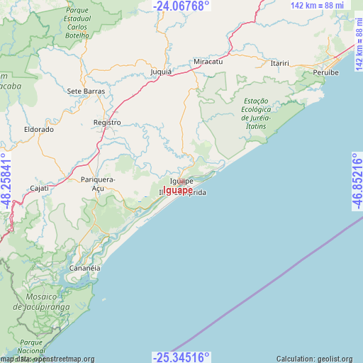
Iguape GPS coordinates[2]
24° 42' 29.016" South, 47° 33' 19.008" West
| Map corner | latitude | longitude |
|---|---|---|
| Upper-left | -24.06768°, | -48.25841° |
| Center: | -24.70806°, | -47.55528° |
| Lower-right: | -25.34516°, | -46.85216° |
| Map W x H: | 142×142 km | = 88.2×88.2mi |
| max Lat: | 2.81972° ⇑87.3% North |
| Iguape: | -24.70806° |
| min Lat: | ⇓12.7% South -33.69111° |
| min Long | Iguape | max Long |
| -72.89583° | -47.55528° | -32.41083° |
| W 37.9%⇐ | ⇒62.1% E |
Elevation
Elevation of Iguape is 8 m = 26 ft, and this is 372.9 m = 1223 ft below average elevation for this country.
| Max E: |
1603 m = 5259 ft | 96.1% |
| Avg. | 380.9 m = 1250 ft | |
| Iguape | 8 m = 26 ft | |
Min E: |
0 m = 0 ft | 3.9% |
See also: Brazil elevation on elevation.city.
Geographical zone
Iguape is located in South temperate zone (between Tropic of Capricorn and the Antarctic Circle). Distance of this Southern Tropic circle is 141.4 km =87.9 mi to North.| Distance of | km | miles | from Iguape |
|---|---|---|---|
| Equator | 2747.3 | 1707.1 | to North |
| Tropic Capricorn | 141.4 | 87.9 | to North |
| Antarctic Circle | 4653.9 | 2891.8 | to South |
| South Pole | 7259.8 | 4511 | to South |


Nearby cities:
15 places around Iguape: (largest is in red/bold)
• Cajati
57.4 km =35.7 mi,  266°
266°
• Cananéia
50.7 km =31.5 mi,  227°
227°
• Capâo Bonito
112.1 km =69.7 mi,  314°
314°
• Itanhaém
97.1 km =60.3 mi,  53°
53°
• Jacupiranga
45.2 km =28.1 mi, 272°
• Juquitiba
99.4 km =61.8 mi,  29°
29°
• Juquiá
43.8 km =27.2 mi,  349°
349°
• Miracatu
48.4 km =30.1 mi,  11°
11°
• Mongaguá
116.7 km =72.5 mi, 54°
• Pariquera Açu
32.9 km =20.4 mi, 268°
• Peruíbe
71 km =44.1 mi, 52°
• Piedade
111.5 km =69.3 mi, 6°
• Pilar do Sul
100.8 km =62.6 mi, 350°
• Registro
38.1 km =23.7 mi, 310°
• São Lourenço da Serra
113.6 km =70.6 mi, 33°
Sources, notices
• [Note1] Compared only with cities in Brazil existing in our database
• [Src1] Map data: © OpenStreetMap contributors (CC-BY-SA)
• [Src2] Other city data from geonames.org with taken over terms of usage.
• [Src3] Geographical zone / Annual Mean Temperature by Robert A. Rohde @ Wikipedia
