Jacupiranga geodata
Jacupiranga (São Paulo) is a populated place; located in Brazil in America/Sao_Paulo (GMT-3) time zone. With population of 11,149 people, there are 1554 cities with bigger population in this country. Compared to other cities in Brazil, 87.3% of cities are located further ↑North; 64.5% of cities are located further →East and 83.5% of cities have higher elevation than Jacupiranga. Note1


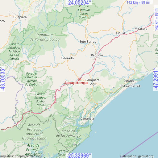
Jacupiranga GPS coordinates[2]
24° 41' 33" South, 48° 0' 7.992" West
| Map corner | latitude | longitude |
|---|---|---|
| Upper-left | -24.05204°, | -48.70535° |
| Center: | -24.6925°, | -48.00222° |
| Lower-right: | -25.32969°, | -47.2991° |
| Map W x H: | 142.1×142.1 km | = 88.3×88.3mi |
| max Lat: | 2.81972° ⇑87.3% North |
| Jacupiranga: | -24.6925° |
| min Lat: | ⇓12.7% South -33.69111° |
| min Long | Jacupiranga | max Long |
| -72.89583° | -48.00222° | -32.41083° |
| W 35.5%⇐ | ⇒64.5% E |
Elevation
Elevation of Jacupiranga is 35 m = 115 ft, and this is 345.9 m = 1135 ft below average elevation for this country.
| Max E: |
1603 m = 5259 ft | 83.5% |
| Avg. | 380.9 m = 1250 ft | |
| Jacupiranga | 35 m = 115 ft | |
Min E: |
0 m = 0 ft | 16.5% |
See also: Brazil elevation on elevation.city.
Geographical zone
Jacupiranga is located in South temperate zone (between Tropic of Capricorn and the Antarctic Circle). Distance of this Southern Tropic circle is 139.6 km =86.7 mi to North.| Distance of | km | miles | from Jacupiranga |
|---|---|---|---|
| Equator | 2745.5 | 1706 | to North |
| Tropic Capricorn | 139.6 | 86.7 | to North |
| Antarctic Circle | 4655.6 | 2892.9 | to South |
| South Pole | 7261.5 | 4512.1 | to South |


Nearby cities:
15 places around Jacupiranga: (largest is in red/bold)
• Antonina
108.7 km =67.5 mi,  221°
221°
• Apiaí
87.4 km =54.3 mi,  283°
283°
• Buri
116.1 km =72.1 mi,  328°
328°
• Cajati
13.1 km =8.1 mi,  248°
248°
• Cananéia
36.6 km =22.7 mi,  167°
167°
• Capâo Bonito
84.1 km =52.3 mi,  335°
335°
• Iguape
45.2 km =28.1 mi,  92°
92°
• Juquiá
55.6 km =34.5 mi,  41°
41°
• Miracatu
71.4 km =44.4 mi,  50°
50°
• Paranaguá
105.7 km =65.7 mi,  209°
209°
• Pariquera Açu
12.5 km =7.8 mi,  101°
101°
• Peruíbe
109.7 km =68.2 mi,  67°
67°
• Pilar do Sul
102 km =63.4 mi,  16°
16°
• Registro
27.9 km =17.3 mi, 35°
• Ribeirão Branco
93.4 km =58 mi,  304°
304°
Sources, notices
• [Note1] Compared only with cities in Brazil existing in our database
• [Src1] Map data: © OpenStreetMap contributors (CC-BY-SA)
• [Src2] Other city data from geonames.org with taken over terms of usage.
• [Src3] Geographical zone / Annual Mean Temperature by Robert A. Rohde @ Wikipedia
