Extrema geodata
Extrema (Minas Gerais) is a populated place; located in Brazil in America/Sao_Paulo (GMT-3) time zone. With population of 13,682 people, there are 1316 cities with bigger population in this country. Compared to other cities in Brazil, 77.2% of cities are located further ↑North; 53.8% of cities are located further →East and 97.2% of cities have lower elevation than Extrema. Note1


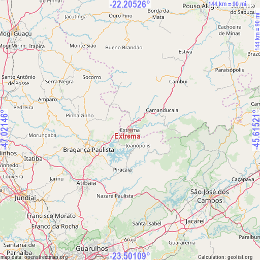
Extrema GPS coordinates[2]
22° 51' 16.992" South, 46° 19' 5.988" West
| Map corner | latitude | longitude |
|---|---|---|
| Upper-left | -22.20526°, | -47.02146° |
| Center: | -22.85472°, | -46.31833° |
| Lower-right: | -23.50109°, | -45.61521° |
| Map W x H: | 144.1×144.1 km | = 89.5×89.5mi |
| max Lat: | 2.81972° ⇑77.2% North |
| Extrema: | -22.85472° |
| min Lat: | ⇓22.8% South -33.69111° |
| min Long | Extrema | max Long |
| -72.89583° | -46.31833° | -32.41083° |
| W 46.2%⇐ | ⇒53.8% E |
Elevation
Elevation of Extrema is 946 m = 3104 ft, and this is 565.1 m = 1854 ft above average elevation for this country.
| Max E: |
1603 m = 5259 ft | 2.8% |
| Extrema | 946 m 3104 ft | |
| Avg. | 380.9 m = 1250 ft | |
Min E: |
0 m = 0 ft | 97.2% |
See also: Brazil elevation on elevation.city.
Geographical zone
Extrema is located in South Torrid zone (between Equator and Tropic of Capricorn). Distance of this Southern Tropic circle is 64.7 km =40.2 mi to South.| Distance of | km | miles | from Extrema |
|---|---|---|---|
| Equator | 2541.2 | 1579 | to North |
| Tropic Capricorn | 64.7 | 40.2 | to South |
| Antarctic Circle | 4860 | 3019.9 | to South |
| South Pole | 7465.9 | 4639.1 | to South |


Nearby cities:
15 places around Extrema: (largest is in red/bold)
• Amparo
48.8 km =30.3 mi,  290°
290°
• Atibaia
37.6 km =23.4 mi,  219°
219°
• Bom Jesus dos Perdões
34.6 km =21.5 mi,  205°
205°
• Bragança Paulista
25.6 km =15.9 mi,  244°
244°
• Bueno Brandão
46.1 km =28.6 mi,  355°
355°
• Camanducaia
20.9 km =13 mi,  58°
58°
• Cambuí
38 km =23.6 mi,  44°
44°
• Jarinu
50.1 km =31.1 mi, 236°
• Joanópolis
9.5 km =5.9 mi,  152°
152°
• Monte Verde
29 km =18 mi,  92°
92°
• Piracaia
22.5 km =14 mi,  190°
190°
• Santa Isabel
52.2 km =32.4 mi,  169°
169°
• Serra Negra
47.6 km =29.6 mi,  304°
304°
• Socorro
36.4 km =22.6 mi,  323°
323°
• Águas de Lindóia
53 km =32.9 mi, 322°
Sources, notices
• [Note1] Compared only with cities in Brazil existing in our database
• [Src1] Map data: © OpenStreetMap contributors (CC-BY-SA)
• [Src2] Other city data from geonames.org with taken over terms of usage.
• [Src3] Geographical zone / Annual Mean Temperature by Robert A. Rohde @ Wikipedia
