Belford Roxo geodata
Belford Roxo (Rio de Janeiro) is a populated place; located in Brazil in America/Sao_Paulo (GMT-3) time zone. With population of 466,096 people, there are 38 cities with bigger population in this country. Compared to other cities in Brazil, 76.4% of cities are located further ↑North; 58.6% of cities are located further ←West and 87.8% of cities have higher elevation than Belford Roxo. Note1


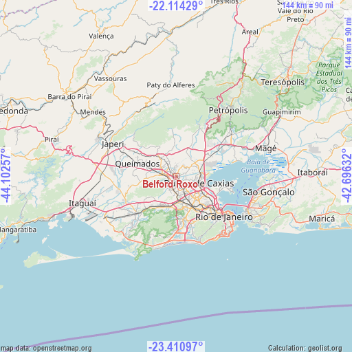
Belford Roxo GPS coordinates[2]
22° 45' 51.012" South, 43° 23' 57.984" West
| Map corner | latitude | longitude |
|---|---|---|
| Upper-left | -22.11429°, | -44.10257° |
| Center: | -22.76417°, | -43.39944° |
| Lower-right: | -23.41097°, | -42.69632° |
| Map W x H: | 144.2×144.2 km | = 89.6×89.6mi |
| max Lat: | 2.81972° ⇑76.4% North |
| Belford Roxo: | -22.76417° |
| min Lat: | ⇓23.6% South -33.69111° |
| min Long | Belford Roxo | max Long |
| -72.89583° | -43.39944° | -32.41083° |
| W 58.6%⇐ | ⇒41.4% E |
Elevation
Elevation of Belford Roxo is 22 m = 72 ft, and this is 358.9 m = 1177 ft below average elevation for this country.
| Max E: |
1603 m = 5259 ft | 87.8% |
| Avg. | 380.9 m = 1250 ft | |
| Belford Roxo | 22 m = 72 ft | |
Min E: |
0 m = 0 ft | 12.2% |
See also: Belford Roxo elevation on elevation.city.
Geographical zone
Belford Roxo is located in South Torrid zone (between Equator and Tropic of Capricorn). Distance of this Southern Tropic circle is 74.8 km =46.5 mi to South.| Distance of | km | miles | from Belford Roxo |
|---|---|---|---|
| Equator | 2531.1 | 1572.8 | to North |
| Tropic Capricorn | 74.8 | 46.5 | to South |
| Antarctic Circle | 4870 | 3026.1 | to South |
| South Pole | 7475.9 | 4645.3 | to South |


Nearby cities:
15 places around Belford Roxo: (largest is in red/bold)
• Duque de Caxias
9.3 km =5.8 mi,  104°
104°
• Itaguaí
39.7 km =24.7 mi,  255°
255°
• Japeri
29.3 km =18.2 mi,  297°
297°
• Miguel Pereira
35.2 km =21.9 mi,  348°
348°
• Nilópolis
5 km =3.1 mi,  197°
197°
• Niterói
33.1 km =20.6 mi,  113°
113°
• Nova Iguaçu
5.3 km =3.3 mi,  275°
275°
• Paracambi
36.1 km =22.4 mi, 298°
• Paty do Alferes
37.4 km =23.2 mi,  356°
356°
• Petrópolis
36.7 km =22.8 mi,  38°
38°
• Queimados
16.9 km =10.5 mi,  288°
288°
• Rio de Janeiro
27.3 km =17 mi,  125°
125°
• Seropédica
31.7 km =19.7 mi,  274°
274°
• São Gonçalo
36.1 km =22.4 mi, 101°
• São João de Meriti
5.2 km =3.2 mi,  147°
147°
Sources, notices
• [Note1] Compared only with cities in Brazil existing in our database
• [Src1] Map data: © OpenStreetMap contributors (CC-BY-SA)
• [Src2] Other city data from geonames.org with taken over terms of usage.
• [Src3] Geographical zone / Annual Mean Temperature by Robert A. Rohde @ Wikipedia
