Itaguaí geodata
Itaguaí (Rio de Janeiro) is a populated place; located in Brazil in America/Sao_Paulo (GMT-3) time zone. With population of 100,752 people, there are 229 cities with bigger population in this country. Compared to other cities in Brazil, 77.2% of cities are located further ↑North; 57.1% of cities are located further ←West and 84.8% of cities have higher elevation than Itaguaí. Note1


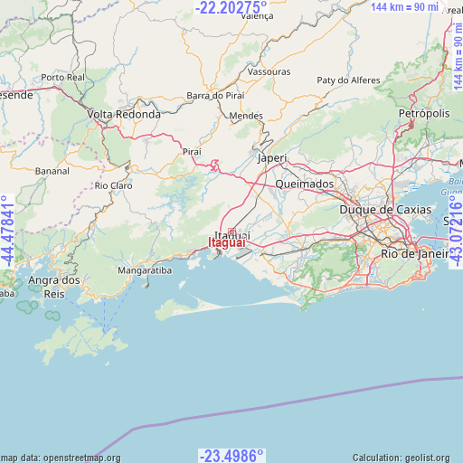
Itaguaí GPS coordinates[2]
22° 51' 7.992" South, 43° 46' 31.008" West
| Map corner | latitude | longitude |
|---|---|---|
| Upper-left | -22.20275°, | -44.47841° |
| Center: | -22.85222°, | -43.77528° |
| Lower-right: | -23.4986°, | -43.07216° |
| Map W x H: | 144.1×144.1 km | = 89.5×89.5mi |
| max Lat: | 2.81972° ⇑77.2% North |
| Itaguaí: | -22.85222° |
| min Lat: | ⇓22.8% South -33.69111° |
| min Long | Itaguaí | max Long |
| -72.89583° | -43.77528° | -32.41083° |
| W 57.1%⇐ | ⇒42.9% E |
Elevation
Elevation of Itaguaí is 31 m = 102 ft, and this is 349.9 m = 1148 ft below average elevation for this country.
| Max E: |
1603 m = 5259 ft | 84.8% |
| Avg. | 380.9 m = 1250 ft | |
| Itaguaí | 31 m = 102 ft | |
Min E: |
0 m = 0 ft | 15.2% |
See also: Itaguaí elevation on elevation.city.
Geographical zone
Itaguaí is located in South Torrid zone (between Equator and Tropic of Capricorn). Distance of this Southern Tropic circle is 65 km =40.4 mi to South.| Distance of | km | miles | from Itaguaí |
|---|---|---|---|
| Equator | 2540.9 | 1578.8 | to North |
| Tropic Capricorn | 65 | 40.4 | to South |
| Antarctic Circle | 4860.2 | 3020 | to South |
| South Pole | 7466.1 | 4639.2 | to South |


Nearby cities:
15 places around Itaguaí: (largest is in red/bold)
• Barra do Piraí
42.8 km =26.6 mi,  353°
353°
• Belford Roxo
39.7 km =24.7 mi,  75°
75°
• Duque de Caxias
48.1 km =29.9 mi, 81°
• Japeri
26.4 km =16.4 mi,  28°
28°
• Mangaratiba
29.7 km =18.5 mi,  246°
246°
• Mendes
36.5 km =22.7 mi,  6°
6°
• Nilópolis
37.4 km =23.2 mi, 82°
• Nova Iguaçu
34.8 km =21.6 mi,  72°
72°
• Paracambi
28 km =17.4 mi, 14°
• Pinheiral
44.3 km =27.5 mi,  328°
328°
• Piraí
27.8 km =17.3 mi, 333°
• Queimados
27.2 km =16.9 mi,  56°
56°
• Rio Claro
39.6 km =24.6 mi,  291°
291°
• Seropédica
13.9 km =8.6 mi, 29°
• São João de Meriti
41.7 km =25.9 mi, 82°
Sources, notices
• [Note1] Compared only with cities in Brazil existing in our database
• [Src1] Map data: © OpenStreetMap contributors (CC-BY-SA)
• [Src2] Other city data from geonames.org with taken over terms of usage.
• [Src3] Geographical zone / Annual Mean Temperature by Robert A. Rohde @ Wikipedia
