Tabatinga geodata
Tabatinga (Amazonas) is a populated place; located in Brazil in America/Manaus (GMT-4) time zone. With population of 28,229 people, there are 703 cities with bigger population in this country. Compared to other cities in Brazil, 90.5% of cities are located further ↓South; 99.6% of cities are located further →East and 74.6% of cities have higher elevation than Tabatinga. Note1


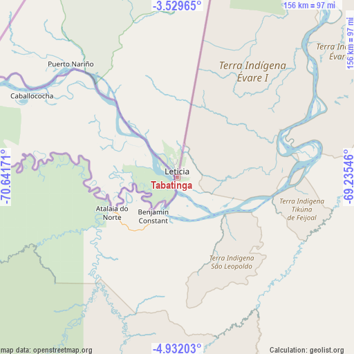
Tabatinga GPS coordinates[2]
4° 13' 52.176" South, 69° 56' 18.888" West
| Map corner | latitude | longitude |
|---|---|---|
| Upper-left | -3.52965°, | -70.64171° |
| Center: | -4.23116°, | -69.93858° |
| Lower-right: | -4.93203°, | -69.23546° |
| Map W x H: | 155.9×155.9 km | = 96.9×96.9mi |
| max Lat: | 2.81972° ⇑9.5% North |
| Tabatinga: | -4.23116° |
| min Lat: | ⇓90.5% South -33.69111° |
| min Long | Tabatinga | max Long |
| -72.89583° | -69.93858° | -32.41083° |
| W 0.4%⇐ | ⇒99.6% E |
Elevation
Elevation of Tabatinga is 80 m = 262 ft, and this is 300.9 m = 987 ft below average elevation for this country.
| Max E: |
1603 m = 5259 ft | 74.6% |
| Avg. | 380.9 m = 1250 ft | |
| Tabatinga | 80 m = 262 ft | |
Min E: |
0 m = 0 ft | 25.4% |
See also: Brazil elevation on elevation.city.
Geographical zone
Tabatinga is located in South Torrid zone (between Equator and Tropic of Capricorn). Distance of Equator is 470.5 km =292.4 mi to North.| Distance of | km | miles | from Tabatinga |
|---|---|---|---|
| Equator | 470.5 | 292.4 | to North |
| Tropic Capricorn | 2135.5 | 1326.9 | to South |
| Antarctic Circle | 6930.7 | 4306.5 | to South |
| South Pole | 9536.6 | 5925.8 | to South |


Nearby cities:
9 places around Tabatinga: (largest is in red/bold)
• Benjamin Constant
19.1 km =11.9 mi,  212°
212°
• Carauari
344.9 km =214.3 mi,  102°
102°
• Eirunepé
270.2 km =167.9 mi,  178°
178°
• Envira
342.6 km =212.9 mi,  185°
185°
• Feijó
439.9 km =273.3 mi, 186°
• Jutaí
156.4 km =97.2 mi,  132°
132°
• Santo Antônio do Içá
254.9 km =158.4 mi,  60°
60°
• São Paulo de Olivença
151.6 km =94.2 mi,  51°
51°
• Tonantins
281.1 km =174.7 mi, 57°
Sources, notices
• [Note1] Compared only with cities in Brazil existing in our database
• [Src1] Map data: © OpenStreetMap contributors (CC-BY-SA)
• [Src2] Other city data from geonames.org with taken over terms of usage.
• [Src3] Geographical zone / Annual Mean Temperature by Robert A. Rohde @ Wikipedia
