Santo Antônio do Içá geodata
Santo Antônio do Içá (Amazonas) is a populated place; located in Brazil in America/Manaus (GMT-4) time zone. With population of 9,302 people, there are 1699 cities with bigger population in this country. Compared to other cities in Brazil, 95.1% of cities are located further ↓South; 99.2% of cities are located further →East and 76.6% of cities have higher elevation than Santo Antônio do Içá. Note1
Current local time in Santo Antônio do Içá:
12:01 AM, WednesdayDifference from your time zone: hours


Santo Antônio do Içá GPS coordinates[2]
3° 6' 7.992" South, 67° 56' 22.992" West
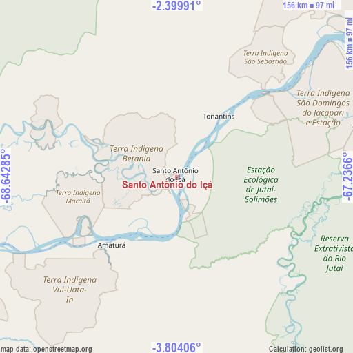
| Map corner | latitude | longitude |
|---|---|---|
| Upper-left | -2.39991°, | -68.64285° |
| Center: | -3.10222°, | -67.93972° |
| Lower-right: | -3.80406°, | -67.2366° |
| Map W x H: | 156.1×156.1 km | = 97×97mi |
| max Lat: | 2.81972° ⇑4.9% North |
| Santo Antônio do Içá: | -3.10222° |
| min Lat: | ⇓95.1% South -33.69111° |
| min Long | Santo Antônio | max Long |
| -72.89583° | -67.93972° | -32.41083° |
| W 0.8%⇐ | ⇒99.2% E |
Elevation
Elevation of Santo Antônio do Içá is 68 m = 223 ft, and this is 312.9 m = 1027 ft below average elevation for this country.
| Max E: |
1603 m = 5259 ft | 76.6% |
| Avg. | 380.9 m = 1250 ft | |
| Santo Antônio do Içá | 68 m = 223 ft | |
Min E: |
0 m = 0 ft | 23.4% |
See also: Brazil elevation on elevation.city.
Geographical zone
Santo Antônio do Içá is located in South Torrid zone (between Equator and Tropic of Capricorn). Distance of Equator is 344.9 km =214.3 mi to North.| Distance of | km | miles | from Santo Antônio do Içá |
|---|---|---|---|
| Equator | 344.9 | 214.3 | to North |
| Tropic Capricorn | 2261 | 1404.9 | to South |
| Antarctic Circle | 7056.2 | 4384.5 | to South |
| South Pole | 9662.1 | 6003.7 | to South |


Nearby cities:
13 places around Santo Antônio do Içá: (largest is in red/bold)
• Alvarães
348.4 km =216.5 mi,  92°
92°
• Benjamin Constant
271.9 km =169 mi,  238°
238°
• Carauari
229.4 km =142.5 mi,  149°
149°
• Fonte Boa
215.4 km =133.8 mi,  72°
72°
• Jutaí
254.7 km =158.3 mi,  204°
204°
• Maraã
320 km =198.8 mi,  63°
63°
• Santa Isabel do Rio Negro
441.2 km =274.1 mi,  47°
47°
• São Gabriel da Cachoeira
345.1 km =214.4 mi,  15°
15°
• São Paulo de Olivença
108 km =67.1 mi,  253°
253°
• Tabatinga
254.9 km =158.4 mi, 240°
• Tefé
358.6 km =222.8 mi, 94°
• Tonantins
29.7 km =18.5 mi,  30°
30°
• Uarini
314.6 km =195.5 mi, 87°
Sources, notices
• [Note1] Compared only with cities in Brazil existing in our database
• [Src1] Map data: © OpenStreetMap contributors (CC-BY-SA)
• [Src2] Other city data from geonames.org with taken over terms of usage.
• [Src3] Geographical zone / Annual Mean Temperature by Robert A. Rohde @ Wikipedia
