Paulo Ramos geodata
Paulo Ramos (Maranhão) is a seat of a second-order administrative division; located in Brazil in America/Fortaleza (GMT-3) time zone. In our database, there are 2019 cities with bigger population. Compared to other cities in Brazil, 89.6% of cities are located further ↓South; 50.2% of cities are located further ←West and 77.1% of cities have higher elevation than Paulo Ramos. Note1


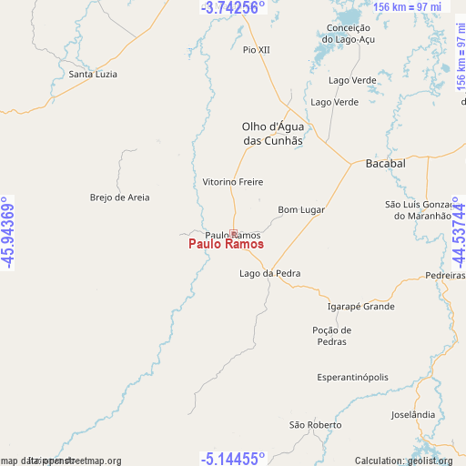
Paulo Ramos GPS coordinates[2]
4° 26' 38.004" South, 45° 14' 26.016" West
| Map corner | latitude | longitude |
|---|---|---|
| Upper-left | -3.74256°, | -45.94369° |
| Center: | -4.44389°, | -45.24056° |
| Lower-right: | -5.14455°, | -44.53744° |
| Map W x H: | 155.9×155.9 km | = 96.9×96.9mi |
| max Lat: | 2.81972° ⇑10.4% North |
| Paulo Ramos: | -4.44389° |
| min Lat: | ⇓89.6% South -33.69111° |
| min Long | Paulo Ramos | max Long |
| -72.89583° | -45.24056° | -32.41083° |
| W 50.2%⇐ | ⇒49.8% E |
Elevation
Elevation of Paulo Ramos is 64 m = 210 ft, and this is 316.9 m = 1040 ft below average elevation for this country.
| Max E: |
1603 m = 5259 ft | 77.1% |
| Avg. | 380.9 m = 1250 ft | |
| Paulo Ramos | 64 m = 210 ft | |
Min E: |
0 m = 0 ft | 22.9% |
See also: Brazil elevation on elevation.city.
Geographical zone
Paulo Ramos is located in South Torrid zone (between Equator and Tropic of Capricorn). Distance of Equator is 494.1 km =307 mi to North.| Distance of | km | miles | from Paulo Ramos |
|---|---|---|---|
| Equator | 494.1 | 307 | to North |
| Tropic Capricorn | 2111.8 | 1312.2 | to South |
| Antarctic Circle | 6907.1 | 4291.9 | to South |
| South Pole | 9512.9 | 5911 | to South |


Nearby cities:
15 places around Paulo Ramos: (largest is in red/bold)
• Bacabal
52.6 km =32.7 mi,  71°
71°
• Dom Pedro
110.7 km =68.8 mi,  126°
126°
• Esperantinópolis
75.4 km =46.9 mi, 128°
• Lago da Pedra
17.5 km =10.9 mi,  0°
0°
• Lago dos Rodrigues
34.5 km =21.4 mi,  123°
123°
• Monção
105.9 km =65.8 mi,  359°
359°
• Paulo Ramos
26 km =16.2 mi,  14°
14°
• Pindaré Mirim
93.6 km =58.2 mi,  353°
353°
• Pio XII
68.7 km =42.7 mi, 8°
• Poção de Pedras
49.9 km =31 mi, 119°
• Santa Inês
87.8 km =54.6 mi, 349°
• São Mateus do Maranhão
95.9 km =59.6 mi,  62°
62°
• Tuntum
111.8 km =69.5 mi,  144°
144°
• Vitorino Freire
44.6 km =27.7 mi, 0°
• Vitória do Mearim
116.6 km =72.5 mi,  20°
20°
Sources, notices
• [Note1] Compared only with cities in Brazil existing in our database
• [Src1] Map data: © OpenStreetMap contributors (CC-BY-SA)
• [Src2] Other city data from geonames.org with taken over terms of usage.
• [Src3] Geographical zone / Annual Mean Temperature by Robert A. Rohde @ Wikipedia
