Santa Inês geodata
Santa Inês (Maranhão) is a populated place; located in Brazil in America/Fortaleza (GMT-3) time zone. With population of 67,424 people, there are 334 cities with bigger population in this country. Compared to other cities in Brazil, 92.9% of cities are located further ↓South; 50.5% of cities are located further →East and 84.8% of cities have higher elevation than Santa Inês. Note1


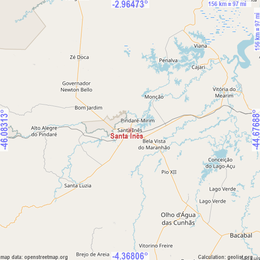
Santa Inês GPS coordinates[2]
3° 40' 0.012" South, 45° 22' 48" West
| Map corner | latitude | longitude |
|---|---|---|
| Upper-left | -2.96473°, | -46.08313° |
| Center: | -3.66667°, | -45.38° |
| Lower-right: | -4.36806°, | -44.67688° |
| Map W x H: | 156×156 km | = 96.9×96.9mi |
| max Lat: | 2.81972° ⇑7.1% North |
| Santa Inês: | -3.66667° |
| min Lat: | ⇓92.9% South -33.69111° |
| min Long | Santa Inês | max Long |
| -72.89583° | -45.38° | -32.41083° |
| W 49.5%⇐ | ⇒50.5% E |
Elevation
Elevation of Santa Inês is 31 m = 102 ft, and this is 349.9 m = 1148 ft below average elevation for this country.
| Max E: |
1603 m = 5259 ft | 84.8% |
| Avg. | 380.9 m = 1250 ft | |
| Santa Inês | 31 m = 102 ft | |
Min E: |
0 m = 0 ft | 15.2% |
See also: Santa Inês elevation on elevation.city.
Geographical zone
Santa Inês is located in South Torrid zone (between Equator and Tropic of Capricorn). Distance of Equator is 407.7 km =253.3 mi to North.| Distance of | km | miles | from Santa Inês |
|---|---|---|---|
| Equator | 407.7 | 253.3 | to North |
| Tropic Capricorn | 2198.2 | 1365.9 | to South |
| Antarctic Circle | 6993.5 | 4345.6 | to South |
| South Pole | 9599.4 | 5964.8 | to South |


Nearby cities:
15 places around Santa Inês: (largest is in red/bold)
• Anajatuba
95.5 km =59.3 mi,  62°
62°
• Araguanã
85.9 km =53.4 mi,  338°
338°
• Arari
70.7 km =43.9 mi,  70°
70°
• Bacabal
95.3 km =59.2 mi,  136°
136°
• Lago da Pedra
70.7 km =43.9 mi,  167°
167°
• Matinha
73.8 km =45.9 mi,  31°
31°
• Monção
24.1 km =15 mi,  36°
36°
• Paulo Ramos
64.9 km =40.3 mi,  160°
160°
• Paulo Ramos
87.8 km =54.6 mi, 169°
• Penalva
47.3 km =29.4 mi, 28°
• Pindaré Mirim
7.7 km =4.8 mi, 32°
• Pio XII
31.3 km =19.4 mi,  126°
126°
• Viana
64.9 km =40.3 mi, 40°
• Vitorino Freire
44.7 km =27.8 mi, 159°
• Vitória do Mearim
60.9 km =37.8 mi, 68°
Sources, notices
• [Note1] Compared only with cities in Brazil existing in our database
• [Src1] Map data: © OpenStreetMap contributors (CC-BY-SA)
• [Src2] Other city data from geonames.org with taken over terms of usage.
• [Src3] Geographical zone / Annual Mean Temperature by Robert A. Rohde @ Wikipedia
