Pindaré Mirim geodata
Pindaré Mirim (Maranhão) is a populated place; located in Brazil in America/Fortaleza (GMT-3) time zone. With population of 22,933 people, there are 833 cities with bigger population in this country. Compared to other cities in Brazil, 93.1% of cities are located further ↓South; 50.3% of cities are located further →East and 86.9% of cities have higher elevation than Pindaré Mirim. Note1


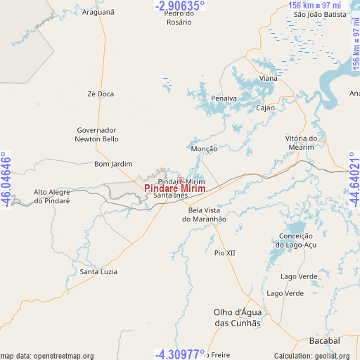
Pindaré Mirim GPS coordinates[2]
3° 36' 29.988" South, 45° 20' 35.988" West
| Map corner | latitude | longitude |
|---|---|---|
| Upper-left | -2.90635°, | -46.04646° |
| Center: | -3.60833°, | -45.34333° |
| Lower-right: | -4.30977°, | -44.64021° |
| Map W x H: | 156×156.1 km | = 96.9×97mi |
| max Lat: | 2.81972° ⇑6.9% North |
| Pindaré Mirim: | -3.60833° |
| min Lat: | ⇓93.1% South -33.69111° |
| min Long | Pindaré Mirim | max Long |
| -72.89583° | -45.34333° | -32.41083° |
| W 49.7%⇐ | ⇒50.3% E |
Elevation
Elevation of Pindaré Mirim is 24 m = 79 ft, and this is 356.9 m = 1171 ft below average elevation for this country.
| Max E: |
1603 m = 5259 ft | 86.9% |
| Avg. | 380.9 m = 1250 ft | |
| Pindaré Mirim | 24 m = 79 ft | |
Min E: |
0 m = 0 ft | 13.1% |
See also: Brazil elevation on elevation.city.
Geographical zone
Pindaré Mirim is located in South Torrid zone (between Equator and Tropic of Capricorn). Distance of Equator is 401.2 km =249.3 mi to North.| Distance of | km | miles | from Pindaré Mirim |
|---|---|---|---|
| Equator | 401.2 | 249.3 | to North |
| Tropic Capricorn | 2204.7 | 1369.9 | to South |
| Antarctic Circle | 7000 | 4349.6 | to South |
| South Pole | 9605.9 | 5968.8 | to South |


Nearby cities:
15 places around Pindaré Mirim: (largest is in red/bold)
• Anajatuba
89 km =55.3 mi,  64°
64°
• Araguanã
81.6 km =50.7 mi,  334°
334°
• Arari
64.8 km =40.3 mi,  74°
74°
• Lago da Pedra
76.3 km =47.4 mi,  171°
171°
• Matinha
66.1 km =41.1 mi,  31°
31°
• Monção
16.5 km =10.3 mi,  38°
38°
• Paulo Ramos
69.9 km =43.4 mi, 165°
• Paulo Ramos
93.6 km =58.2 mi, 173°
• Penalva
39.7 km =24.7 mi, 28°
• Pio XII
32.7 km =20.3 mi,  139°
139°
• Santa Inês
7.7 km =4.8 mi,  212°
212°
• São João Batista
93.9 km =58.3 mi, 39°
• Viana
57.3 km =35.6 mi, 41°
• Vitorino Freire
49.7 km =30.9 mi, 166°
• Vitória do Mearim
54.9 km =34.1 mi, 72°
Sources, notices
• [Note1] Compared only with cities in Brazil existing in our database
• [Src1] Map data: © OpenStreetMap contributors (CC-BY-SA)
• [Src2] Other city data from geonames.org with taken over terms of usage.
• [Src3] Geographical zone / Annual Mean Temperature by Robert A. Rohde @ Wikipedia
