Mochudi geodata
Mochudi (Kgatleng) is a seat of a first-order administrative division; located in Botswana in Africa/Gaborone (GMT+2) time zone. With population of 36,962 people, there are 9 cities with bigger population in this country. Compared to other cities in Botswana, 70.5% of cities are located further ↑North; 59% of cities are located further ←West and 66.7% of cities have higher elevation than Mochudi. Note1


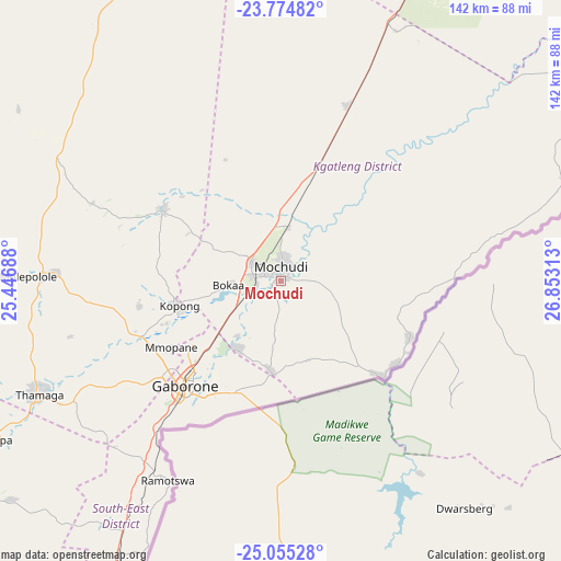
Mochudi GPS coordinates[2]
24° 25' 0.012" South, 26° 9' 0" East
| Map corner | latitude | longitude |
|---|---|---|
| Upper-left | -23.77482°, | 25.44688° |
| Center: | -24.41667°, | 26.15° |
| Lower-right: | -25.05528°, | 26.85313° |
| Map W x H: | 142.4×142.4 km | = 88.5×88.5mi |
| max Lat: | -17.80165° ⇑70.5% North |
| Mochudi: | -24.41667° |
| min Lat: | ⇓29.5% South -26.9° |
| min Long | Mochudi | max Long |
| 20.06667° | 26.15° | 28.74946° |
| W 59%⇐ | ⇒41% E |
Elevation
Elevation of Mochudi is 952 m = 3123 ft, and this is 63 m = 207 ft below average elevation for this country.
| Max E: |
1406 m = 4613 ft | 66.7% |
| Avg. | 1015 m = 3330 ft | |
| Mochudi | 952 m = 3123 ft | |
Min E: |
676 m = 2218 ft | 33.3% |
See also: Botswana elevation on elevation.city.
Geographical zone
Mochudi is located in South temperate zone (between Tropic of Capricorn and the Antarctic Circle). Distance of this Southern Tropic circle is 109 km =67.7 mi to North.| Distance of | km | miles | from Mochudi |
|---|---|---|---|
| Equator | 2714.9 | 1687 | to North |
| Tropic Capricorn | 109 | 67.7 | to North |
| Antarctic Circle | 4686.3 | 2911.9 | to South |
| South Pole | 7292.2 | 4531.2 | to South |


Nearby cities:
15 places around Mochudi: (largest is in red/bold)
• Bokaa
14 km =8.7 mi,  254°
254°
• Dumadumana
33.7 km =20.9 mi,  235°
235°
• Gaborone
36 km =22.4 mi,  222°
222°
• Galekgatshwane
36.5 km =22.7 mi, 251°
• Gaphatshwe
36.4 km =22.6 mi, 241°
• Kgaphamadi
26.2 km =16.3 mi, 239°
• Kopong
28 km =17.4 mi, 254°
• Lenchwe Le Tau
30.6 km =19 mi,  276°
276°
• Metsemotlhaba
38.2 km =23.7 mi, 246°
• Mmathubudukwane
35.2 km =21.9 mi,  125°
125°
• Mmopone
32.5 km =20.2 mi, 239°
• Mogoditshane
37.1 km =23.1 mi,  230°
230°
• Mononyane
40.8 km =25.4 mi, 250°
• Nkoyaphiri
40.2 km =25 mi, 233°
• Pilane
4.1 km =2.5 mi,  204°
204°
Sources, notices
• [Note1] Compared only with cities in Botswana existing in our database
• [Src1] Map data: © OpenStreetMap contributors (CC-BY-SA)
• [Src2] Other city data from geonames.org with taken over terms of usage.
• [Src3] Geographical zone / Annual Mean Temperature by Robert A. Rohde @ Wikipedia
